osm2cdr.com
Ready map · OSM data

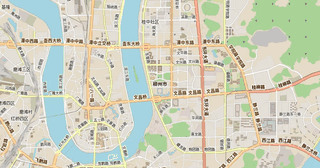
Map of Guangxi

Region · China · 246,696 km2

A ready-made vector map with buildings, roads and features — for CAD, GIS and print. Download after signing in.

Choose a format
All 128 formats Customize your area
128 formatsOSM datadownload after signing in
Map of Guangxi
Guangxi
China
N
© OpenStreetMap
Boundary · Guangxi · OpenStreetMap
BuildingsRoadsWaterGreeneryBoundary

Map passport

246,696 km2
Area
46 739
Buildings
22 312
Points of interest
Typeregion
Coordinates23.73° N, 108.79° E
OSM data2026-10-05
Customize the map for yourself

Open the area of Guangxi in the constructor and change layers, style, format and coordinate system for your task.

Open in constructor

Map defaults

This is how the map is built by default — every parameter can be changed in the constructor.

Format
PDF choose
Layers
Roads, Buildings, Water, Greenery, POIchange
Style
Standard (colour)change
Detail
overview (auto)change
House numbers
not visible at this scalechange
Points of interest
not visible at this scalechange
Coordinate system
WGS 84 (auto)change
Sheet size
Relief and grid

Download the map of Guangxi in 128 formats

The same OpenStreetMap dataset — in the format for your software. Pick by task: CAD, vector, GIS, 3D or print.

Popular formatsthe most common formats
MOST COMMON
PDFfor printing and viewing.pdf · ≈ 7.1 MB
CDRfor CorelDRAW.cdr · ≈ 1.3 MB
SVGfor Illustrator, Inkscape, web.svg · ≈ 1.4 MB
GeoJSONfor QGIS and web maps.geojson · ≈ 3.3 MB
DWGfor AutoCAD, nanoCAD, BricsCAD.dwg · ≈ 314 KB
CADdrafting and design
DWGFREE
AutoCAD.dwg · ≈ 550 KB
DXFFREE
CAD exchange.dxf · ≈ 4.5 MB
CDRFREE
CorelDRAW.cdr · ≈ 196 KB
DGNFREE
MicroStation.dgn · ≈ 876 KB
Vectorillustration and web
SVGFREE
Web · vector.svg · ≈ 1.5 MB
AIFREE
Illustrator.ai · ≈ 1.2 MB
EPSFREE
Print production.eps · ≈ 1.2 MB
PDFFREE
Vector · print.pdf · ≈ 1.3 MB
GISgeo-referenced data
GeoJSONFREE
GIS · data.geojson · ≈ 3 MB
ShapefileFREE
QGIS · ArcGIS.shp · ≈ 385 KB
KMLFREE
Google Earth.kml · ≈ 2.9 MB
GeoPackageFREE
GeoPackage.gpkg · ≈ 1.6 MB
3Dvolume and models
STLFREE
3D printing.stl · ≈ 84 KB
OBJFREE
3D model.obj · ≈ 33 KB
glTFFREE
3D · web.gltf · ≈ 61 KB
DAEFREE
Collada.dae · ≈ 56 KB
Printraster and layouts
PNGFREE
Raster · transparency.png · ≈ 1007 KB
JPGFREE
Raster.jpg · ≈ 256 KB
PDFFREE
Print layout.pdf · ≈ 1.3 MB
TIFFFREE
Print production.tif · ≈ 2.3 MB
Open all 128 formats

Maps of China

All places within the territory — every map is ready to download.

About Guangxi

Guangxi is a ready-made vector map based on OpenStreetMap data. It is not an image but structured layers of buildings, roads, water bodies, greenery and points of interest that can be edited in any professional software. The territory belongs to the «China» region and covers an area of 246,696 km2 within administrative boundaries.

The map includes 46 739 buildings and 22 312 points of interest. Each layer can be turned on or off before download, and the data preserves the original OpenStreetMap classification. Green areas cover about 9.9% of the territory.

The map works well as an underlay in AutoCAD and CorelDRAW, for loading layers into QGIS and ArcGIS, preparing printed schemes and plans, or as a basis for design and navigation. 128 formats are available — from DWG, DXF and SVG to GeoJSON, Shapefile and 3D models, in the WGS 84 coordinate system.

246 695.8 km²Area
46 739Buildings
1 475Water bodies
128formats
WGS 84coordinate system

What's inside the map of Guangxi

The map covers the entire area of Guangxi within administrative boundaries — 246,696 km2. Green areas cover 9.9% of the territory. Each layer can be turned on or off before download.

46 739buildings
Buildings on separate layers
residential11744
commercial1849
industrial2199
22 312POI
Points of interest
banks420
cafes424
fuel stations807
Main streets
荔波-隆安公路坡洪-弄陇公路来宾-下坳公路融安-下老公路百色-逊家坳公路龙和-岳圩公路
Landmarks · 6
›天等县文化馆
›北部湾海洋文化博物馆
›越南共产党驻龙州秘密机关旧址
›岑溪博物馆
›广西电信博物馆
›那坡历史博物馆

What the map of Guangxi looks like

The same place in three render styles. Buildings, roads, water and greenery carry over into every format losslessly.

Blueprint (CAD) — map of Guangxi
Blueprint (CAD)
Outlines on a dark background — for DWG and DXF
Standard vector — map of Guangxi
Standard vector
A colour map with buildings, roads and greenery
Print layout — map of Guangxi
Print layout
A ready layout for PDF and print production
Guangxi in numbers
Area246 695.8 km²
Buildings46 739
Water bodies1 475
Green areas47 806.4 km²
Green share9.9%
Stations and stops3 958
OSM data as of2026-07-16
What is on the map of Guangxi
Points of interest22 312
Cafés and restaurants2 693
Shops4 697
Schools1 639
Universities230
Hospitals315
Pharmacies294
Hotels1 001
Parks531

Streets and roads

Roads classified by type — according to OpenStreetMap data.

Named streets
›荔波-隆安公路 · 260,6 km
›坡洪-弄陇公路 · 213 km
›来宾-下坳公路 · 211,3 km
›融安-下老公路 · 166,4 km
›百色-逊家坳公路 · 153,9 km
›龙和-岳圩公路 · 140,3 km
›梧州-迁江公路 · 134,3 km
›302省道 · 120,9 km

Frequently asked questions

Open osm2cdr.com, select the target area on the map, choose a format, and start export. Most maps are ready in a few seconds.
Map of Guangxi is available in 128 formats: CDR, DWG, DXF, SVG, AI, EPS, PDF, PNG, GeoJSON, KML, Shapefile, GeoTIFF and others.
Pick a format: all 128 formats are available, with no area limits. Download after signing in to the site; you see the price before you pay.
The service uses OpenStreetMap data, updated monthly.
Generation time depends on the area size. You will receive an email notification when ready.