osm2cdr.com
Ready map · OSM data

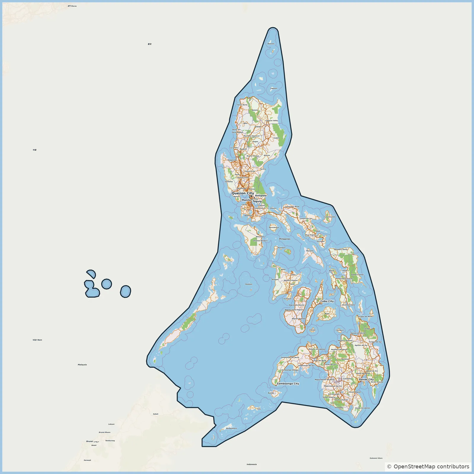
Map of Philippines

Elevation of Philippines: 0 m · 0 ft

Country · 1.0M km2

A ready-made vector map with buildings, roads and features — for CAD, GIS and print. Download after signing in.

Choose a format
All 128 formats Customize your area
128 formatsOSM datadownload after signing in
N
© OpenStreetMap
Boundary · Philippines · OpenStreetMap
BuildingsRoadsWaterGreeneryBoundary

Map passport

1.0M km2
Area
1 092 243
Buildings
361 081 km
Roads
253 957
Points of interest
Typecountry
Coordinates11.51° N, 114.41° E
Elevation≈0 m
OSM data2026-10-26
Customize the map for yourself

Open the area of Philippines in the constructor and change layers, style, format and coordinate system for your task.

Open in constructor

Map defaults

This is how the map is built by default — every parameter can be changed in the constructor.

Format
PDF choose
Layers
Roads, Buildings, Water, Greenery, POIchange
Style
Standard (colour)change
Detail
overview (auto)change
House numbers
not visible at this scalechange
Points of interest
not visible at this scalechange
Coordinate system
WGS 84 (auto)change
Sheet size
Relief and grid

Download the map of Philippines in 128 formats

The same OpenStreetMap dataset — in the format for your software. Pick by task: CAD, vector, GIS, 3D or print.

Popular formatsthe most common formats
MOST COMMON
PDFfor printing and viewing.pdf · ≈ 10.7 MB
CDRfor CorelDRAW.cdr · ≈ 2.4 MB
SVGfor Illustrator, Inkscape, web.svg · ≈ 18.4 MB
GeoJSONfor QGIS and web maps.geojson · ≈ 23.5 MB
DWGfor AutoCAD, nanoCAD, BricsCAD.dwg · ≈ 6.7 MB
CADdrafting and design
DWGFREE
AutoCAD.dwg · ≈ 6.7 MB
DXFFREE
CAD exchange.dxf · ≈ 56.4 MB
CDRFREE
CorelDRAW.cdr · ≈ 2.4 MB
DGNFREE
MicroStation.dgn · ≈ 10.7 MB
Vectorillustration and web
SVGFREE
Web · vector.svg · ≈ 18.4 MB
AIFREE
Illustrator.ai · ≈ 15.1 MB
EPSFREE
Print production.eps · ≈ 14.7 MB
Vector PDFFREE
Vector · print.pdf · ≈ 15.7 MB
GISgeo-referenced data
GeoJSONFREE
GIS · data.geojson · ≈ 23.5 MB
ShapefileFREE
QGIS · ArcGIS.shp · ≈ 3 MB
KMLFREE
Google Earth.kml · ≈ 22.7 MB
GeoPackageFREE
GeoPackage.gpkg · ≈ 12.9 MB
3Dvolume and models
STLFREE
3D printing.stl · ≈ 1 MB
OBJFREE
3D model.obj · ≈ 409 KB
glTFFREE
3D · web.gltf · ≈ 760 KB
DAEFREE
Collada.dae · ≈ 702 KB
Printraster and layouts
PNGFREE
Raster · transparency.png · ≈ 12.3 MB
JPGFREE
Raster.jpg · ≈ 3.1 MB
Vector PDFFREE
Print layout.pdf · ≈ 15.7 MB
TIFFFREE
Print production.tif · ≈ 29.3 MB
Open all 128 formats

Maps of Philippines

All places within the territory — every map is ready to download.

Regions · 34

Major cities · 98

Quezon City
Quezon City
City · 2.9M
Davao City
Davao City
City · 1.8M
Manila
Manila
City · 1.8M
Caloocan
Caloocan
City · 1.7M
Zamboanga City
Zamboanga City
City · 1.0M
Cebu City
Cebu City
City · 965K
Taguig
Taguig
City · 886K
Pasig
Pasig
City · 803K
Dasmariñas
Dasmariñas
City · 744K
Cagayan de Oro
Cagayan de Oro
City · 741K
Valenzuela
Valenzuela
City · 714K
General Santos
General Santos
City · 697K
Parañaque
Parañaque
City · 689K
Bacoor
Bacoor
City · 661K
San Jose del Monte
San Jose del Monte
City · 651K
Bacolod
Bacolod
City · 624K
Las Piñas
Las Piñas
City · 615K
Biñan
Biñan
City · 584K
Calamba
Calamba
City · 575K
Muntinlupa
Muntinlupa
City · 552K
Lapu-Lapu
Lapu-Lapu
City · 497K
Imus
Imus
City · 496K
General Trias
General Trias
City · 482K
Iloilo City
Iloilo City
City · 473K
Angeles
Angeles
City · 462K
Marikina
Marikina
City · 456K
Pasay
Pasay
City · 453K
Santa Rosa
Santa Rosa
City · 430K
Taytay
Taytay
City · 397K
Antipolo
Antipolo
City · 887K
Cainta
Cainta
City · 386K
Butuan
Butuan
City · 385K
Tarlac City
Tarlac City
City · 385K
Baguio
Baguio
City · 368K
Iligan
Iligan
City · 368K
Malabon
Malabon
City · 365K
Cabuyao
Cabuyao
City · 365K
Mandaue
Mandaue
City · 364K
San Fernando
San Fernando
City · 354K
San Pedro
San Pedro
City · 348K
Lipa
Lipa
City · 332K
Batangas City
Batangas City
City · 329K
Cotabato City
Cotabato City
City · 325K
Puerto Princesa
Puerto Princesa
City · 316K
Binangonan
Binangonan
City · 313K
Tanza
Tanza
City · 312K
Makati
Makati
City · 309K
San Pablo
San Pablo
City · 300K
Tagum
Tagum
City · 296K
Mabalacat
Mabalacat
City · 293K
Santa Maria
Santa Maria
City · 289K
Lucena
Lucena
City · 278K
Olongapo
Olongapo
City · 264K
Malolos
Malolos
City · 261K
Tacloban
Tacloban
City · 259K
Marilao
Marilao
City · 254K
Navotas
Navotas
City · 247K
Ormoc
Ormoc
City · 230K
City of Meycauayan
City of Meycauayan
City · 225K
Kabankalan
Kabankalan
City · 210K
Legazpi
Legazpi
City · 209K
Marawi
Marawi
City · 207K
Talomo District
Talomo District
City · 444K
Tanauan
Tanauan
City · 193K
Bago
Bago
City · 192K
San Carlos
San Carlos
City · 188K
Digos
Digos
City · 188K
General Mariano Alvarez
City · 176K
Dagupan
Dagupan
City · 174K
Lubao
Lubao
City · 173K
Polomolok
Polomolok
City · 172K
San Miguel
San Miguel
City · 172K
Concepcion
Concepcion
City · 169K
Baliwag
Baliwag
City · 168K
Sariaya
Sariaya
City · 161K
Cadiz
Cadiz
City · 161K
Naic
Naic
City · 160K
Capas
Capas
City · 156K
Pandi
Pandi
City · 155K
Mexico
Mexico
City · 154K
Sagay
Sagay
City · 152K
Isabela
Isabela
City · 151K
Mariveles
Mariveles
City · 149K
Mati
Mati
City · 147K
Calapan
Calapan
City · 145K
Arayat
Arayat
City · 144K
Cauayan
Cauayan
City · 143K
San Jose
San Jose
City · 143K
Ozamiz
Ozamiz
City · 141K
Tabaco
Tabaco
City · 140K
Kidapawan
Kidapawan
City · 140K
Candelaria
Candelaria
City · 137K
Silay
Silay
City · 136K
Nasugbu
Nasugbu
City · 136K
Norzagaray
Norzagaray
City · 136K
Buhangin District
Buhangin District
City · 310K
Floridablanca
Floridablanca
City · 135K
San Juan
San Juan
City · 134K

Neighbouring places and regions

Browse to neighbouring cities, districts and regions — each has a ready-made vector map in the same formats.

Neighboring countries

Malaysia880 km · CountryVietnam91 519 289 · 1368 km · CountryChina3336 km · Country

About Philippines

Philippines is a ready-made vector map based on OpenStreetMap data. It is not an image but structured layers of buildings, roads, water bodies, greenery and points of interest that can be edited in any professional software. The map territory covers an area of 1.0M km2 within administrative boundaries.

The map includes 1 092 243 buildings, 361 081 km of roads and streets and 253 957 points of interest. Each layer can be turned on or off before download, and the data preserves the original OpenStreetMap classification. Green areas cover about 2.3% of the territory.

The map works well as an underlay in AutoCAD and CorelDRAW, for loading layers into QGIS and ArcGIS, preparing printed schemes and plans, or as a basis for design and navigation. 128 formats are available — from DWG, DXF and SVG to GeoJSON, Shapefile and 3D models, in the WGS 84 coordinate system.

0 m · 0 ftElevation of Philippines
1 001 599.7 km²Area
361 081 kmRoads and streets
280.9 kmPedestrian ways
128formats
WGS 84coordinate system

What's inside the map of Philippines

The map covers the entire area of Philippines within administrative boundaries — 1.0M km2. Green areas cover 2.3% of the territory. Each layer can be turned on or off before download.

1 092 243buildings
Buildings on separate layers
commercial16439
industrial11218
361 081km
Roads with classification
trunk roads9 487 km
primary roads15 148 km
service roads28 065 km
253 957POI
Points of interest
banks8 772
cafes6 608
fuel stations10 681
Main streets
Puerto Princesa North RoadMindoro West Coastal RoadCatanduanes Circumferential RoadZambales HighwayPuerto Princesa South RoadMalaybalay-Gingoog Road
Landmarks · 6
›Pope John Paul II Tower
›Old Casa Real de Patnongon
›Museo ng Bangko Sentral ng Pilipinas
›Vintage Glasses Museum
›Museo ng Santa Rosa
›Friendship Hall

What the map of Philippines looks like

The same place in three render styles. Buildings, roads, water and greenery carry over into every format losslessly.

Blueprint (CAD) — map of Philippines
Blueprint (CAD)
Outlines on a dark background — for DWG and DXF
Standard vector — map of Philippines
Standard vector
A colour map with buildings, roads and greenery
Print layout — map of Philippines
Print layout
A ready layout for PDF and print production

Make a free Philippines map poster

Philippines in numbers
Area1 001 599.7 km²
Roads and streets361 081 km
Pedestrian ways280.9 km
Buildings1 092 243
Water bodies3 834
Green areas60 207 km²
Green share2.3%
Stations and stops9 121
Elevation range6 m
OSM data as of2026-04-23
What is on the map of Philippines
Points of interest253 957
Cafés and restaurants42 886
Shops102 271
Schools50 192
Universities2 613
Hospitals2 098
Pharmacies6 992
Hotels13 294
Parks2 437

Streets and roads

Roads classified by type — according to OpenStreetMap data.

139075,1 km
residential streets
90971,7 km
unclassified roads
54538,5 km
tertiary roads
28065,7 km
service roads
22212 km
secondary roads
15148,2 km
primary roads
9487,4 km
trunk roads
1035 km
motorways

The street network of Philippines — 361 081 km of roads according to OpenStreetMap data, classified by type.

Named streets
›Puerto Princesa North Road · 254 km
›Mindoro West Coastal Road · 209,6 km
›Catanduanes Circumferential Road · 193,7 km
›Zambales Highway · 160,9 km
›Puerto Princesa South Road · 154,2 km
›Malaybalay-Gingoog Road · 141,9 km
›Antique-Aklan Road · 133,3 km
›Tagbilaran East Road · 132,9 km

Compared to neighbours

How the place compares to neighbours within a 30-kilometre radius.

0 places within a 30 km radius to compare.

Frequently asked questions

Open osm2cdr.com, select the target area on the map, choose a format, and start export. Most maps are ready in a few seconds.
Map of Philippines is available in 128 formats: CDR, DWG, DXF, SVG, AI, EPS, PDF, PNG, GeoJSON, KML, Shapefile, GeoTIFF and others.
Pick a format: all 128 formats are available, with no area limits. Download after signing in to the site; you see the price before you pay.
The service uses OpenStreetMap data, updated monthly.
Generation time depends on the area size. You will receive an email notification when ready.