NetCDF 🌍

NetCDF (Network Common Data Form)

Preço antes do pagamento
.nc · application/x-netcdf

NetCDF is a self-describing binary format for scientific data and the de facto standard in climate science, oceanography, and satellite remote sensing (ERA5, CMIP6, MODIS). On osm2cdr the OSM to .nc export works honestly like this: for each layer we take feature centroids (longitude/latitude) plus their attributes and write them through xarray as variables sharing a feature-index axis. The result is a compact point dataset with metadata (title, source, bbox), not a ready-made climate density grid cube — that would require a separate aggregation step. The file opens in xarray, Panoply, GDAL, and any NetCDF tool.

Dados do OpenStreetMap de 5 de outubro de 2026 · há 24 dias

Exportar NetCDF agora ✨ Beta Aberta — gratuito, sem limites

Principais características

✓Feature centroid coordinates (lon/lat) and attributes — one variable per layer field
✓One .nc file per export, layers merged via xarray.merge with shared global attributes (title, source, bbox)
✓Written via xarray + netCDF4; if absent, a GDAL-driver fallback rasterizes layers into a NetCDF grid
✓Self-describing binary container: metadata lives inside the file, readable in xarray, Panoply, QGIS (GDAL), MATLAB, R
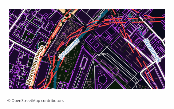
Exemplo de exportação para NetCDF (centro de Moscou, 1×0,5 km)
Exemplo: centro de Moscou, cerca de 1×0,5 km, nível de detalhe médio

Que programa abre ficheiros NetCDF

Os seguintes programas e aplicações podem abrir, editar e trabalhar com ficheiros NetCDF (Network Common Data Form) (.nc) exportados do OSM2CDR:

💻xarray (Python) 💻Panoply (NASA GISS) 💻CDO / NCO (CLI) 🌎QGIS (GDAL NetCDF driver) 💻MATLAB

Características do formato

Quem utiliza mapas NetCDF

🏗
Moving point OSM features of an area into an xarray pipeline for joint analysis with climate data
💻
Archiving POI/building coordinates and attributes in a self-describing format readable without external schemas for decades
📊
Teaching and research tasks needing a NetCDF dataset from a real OSM area to practice CDO/NCO/xarray tooling

Como exportar para NetCDF

1
Selecionar área
Desenhe um retângulo ou polígono no mapa interativo em osm2cdr.ru
2
Escolher NetCDF
Selecione NetCDF (Network Common Data Form) na lista de 127 formatos de exportação disponíveis
3
Exportar
Clique em Exportar e receba o seu ficheiro .nc em 1-5 minutos
4
Descarregar
Descarregue o ficheiro NetCDF pronto e abra-o no xarray (Python)

Mapas populares em NetCDF

Free

Obtenha exportações de mapas em NetCDF (Network Common Data Form)

Descarregue mapas profissionais em NetCDF a partir do OpenStreetMap. Geração instantânea, qualquer área.

Gratuito / exportação
Exportar NetCDF agora →

Perguntas frequentes

Formatos relacionados

Frequentemente exportados em conjunto