
Download Schöder map in GeoJSON format
A map built from OpenStreetMap data, ready to download
Customize the map
Open this place's area in the constructor and adjust everything to your needs
Open in constructor →Map passport
What this map contains by default
This is how the map is built as-is — every setting can be changed in the constructor.
.geojsonAbout GeoJSON
Map of Schöder in GeoJSON: 243 buildings, 22 km of roads, 28 points of interest, 100% green areas — in the WGS 84 coordinate system, units are meters.
Which layers are in the file
This file for the selected area contains:
- Roads
- Buildings
- Water
- Greenery
- Points of interest
What the file carries
The GeoJSON file for Schöder: the whole map comes as a single file, the file is plain text and opens in any editor, all features lie in one collection, and the source layer name stays in the _layer field, OpenStreetMap tags are kept as feature attributes.
File size
The expected size of the GeoJSON file for Schöder is about 1 MB; the exact size depends on the chosen layers and area.
GeoJSON file passport
Estimated from the place's OSM data; exact figures are in the file after the build.
- Layers: 16
- Features by geometry type (estimated): points 28, lines ≈ 109, polygons 379
- Most common tags of the place: highway=secondary ≈ 35, highway=unclassified ≈ 35, highway=service ≈ 14, highway=tertiary ≈ 14, highway=residential ≈ 10, building=religious 3, parking 3, community_centre 2, picnic_table 2, pitch 2
Losses: nothing to lose.
Build recipe: GeoJSON (RFC 7946): one FeatureCollection for all layers, WGS 84 (EPSG:4326), 6 decimal places in coordinates, frame 1.0 × 1.4 km, geometry not simplified; OSM tags → properties.
Coordinate systems
WGS 84 (EPSG:4326), selectable in the wizard
| Category | GIS |
| File extension | .geojson |
| Tier | Open Beta |
How many times GeoJSON was built in the last 90 days
- Schöder
- 0
- Bezirk Murau
- 0
- Whole site
- 1151
- Median file size
- 0.8 MB
- Median build time
- 2.4 s
Medians are based on all builds on the site
How to use GeoJSON for Schöder
- geojson.io — drag the file into a browser window and see the features on the map right away, clicking to inspect properties.
- QGIS (free) — Layer → Add Vector Layer, choose the .geojson.
- Leaflet / Mapbox GL JS / OpenLayers — put the file next to your project and hook it up: in Leaflet that is L.geoJSON(data).addTo(map), in Mapbox GL a source of type geojson.
Programs that open GeoJSON
FAQ: GeoJSON for Schöder
Can I open GeoJSON in a browser?
Yes, on geojson.io or any web app with Leaflet/Mapbox.
Is GeoJSON a free format?
Yes — the format itself is open (RFC 7946), and exporting to it on OSM2CDR is free. There is only one limitation, a technical one: the larger the area, the coarser the detail, so that the file stays a workable size.
Can I load GeoJSON into PostGIS?
Yes, via ogr2ogr or directly with SQL functions like ST_GeomFromGeoJSON.
How do I split the export back into layers?
All the layers arrive in one FeatureCollection, but every feature has a service property _layer — roads, buildings, water, green_areas and so on. Filtering on that field in QGIS, Leaflet or GeoPandas splits the file into separate layers in a single line.
Which projection do the coordinates arrive in?
WGS84 (EPSG:4326) — plain latitude and longitude, as the GeoJSON specification requires. Nothing needs reprojecting for the web or for GIS; if your project is run in a metric system, the conversion is done on the QGIS or PostGIS side.
Other formats for Schöder
All 128 formats for Schöder →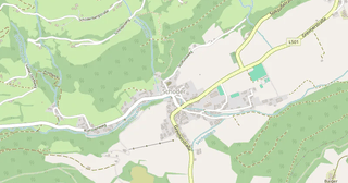
GeoJSON for nearby places
Maps other customers made in this format (GeoJSON)
Barcelona
★★★★★
Пенза
★★★★★
Україна
★★★★★