AVIF 📷

AVIF — AV1 Image File Format

Open Beta
.avif · image/avif

AVIF is a modern raster format built on a key frame of the AV1 video codec inside a HEIF container. On osm2cdr.ru the map is first rendered to PNG and then transcoded to AVIF via Pillow. At comparable visual quality the file is 30–50% lighter than WebP, which noticeably saves bandwidth for mobile users. It is a flat picture of the map, not editable layers: labels and outlines are baked into pixels. Note that the alpha channel is dropped during conversion, so the background becomes opaque.

Exportar AVIF agora ✨ Beta Aberta — gratuito, sem limites

Principais características

30–50% better compression than WebP at the same visual quality
HEIF container with AV1 intra-frame, MIME type image/avif
Configurable quality and encoding speed (defaults: quality 50, speed 6)
A raster snapshot of the map — pixels ready to display, not editable layers
Supported in recent Chrome, Firefox and Safari (~96% of traffic)
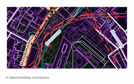
Example AVIF export (central Moscow, 1x0.5 km)
Example: central Moscow, ~1×0.5 km, medium detail

Sobre o formato AVIF

AVIF is a raster format grown out of the AV1 video codec: the picture is encoded as a single key frame and packed into a HEIF container. At the same visual quality the file comes out noticeably lighter than JPEG and appreciably lighter than WebP, which directly saves traffic and speeds up page loading.

The format is chosen where the map is an image on a website: a district preview in a listing card, an article cover, an illustration in a guidebook, a picture for social media. The whole point is the weight: the same pixels reach a mobile user faster and cheaper.

The output is a single .avif file: the map is first rendered to PNG and then recompressed. This is a final picture, not layers — labels, roads and buildings are fixed in pixels and cannot be edited separately. Transparency is not preserved during conversion: the alpha channel is dropped and the background becomes opaque.

Que programa abre ficheiros AVIF

Os seguintes programas e aplicações podem abrir, editar e trabalhar com ficheiros AVIF — AV1 Image File Format (.avif) exportados do OSM2CDR:

🌐Google Chrome 🌐Mozilla Firefox 💻GIMP 💻ImageMagick 🎨Adobe Photoshop (plugin)

Format specifications

Quem utiliza mapas AVIF

🏗
Lightweight district map thumbnails for real-estate sites and travel guides
Light district previews in real estate catalogs and guidebooks — the page loads faster.
💻
Hero and Open Graph images where a low Largest Contentful Paint matters
Covers and pictures for social media, where the weight of an image directly affects how fast the first screen appears.
📊
Delivering static maps via CDN, compiled once and served many times
Static maps on a CDN: the file is encoded once and served to millions of requests.
🎨
Cutting mobile bandwidth without losing label and line readability
Mobile scenarios where every kilobyte counts and the map still has to stay readable.

Como exportar para AVIF

1
Selecionar área
Desenhe um retângulo ou polígono no mapa interativo em osm2cdr.ru
2
Escolher AVIF
Selecione AVIF — AV1 Image File Format na lista de 127 formatos de exportação disponíveis
3
Exportar
Clique em Exportar e receba o seu ficheiro .avif em 1-5 minutos
4
Descarregar
Descarregue o ficheiro AVIF pronto e abra-o no Google Chrome

Como abrir depois da exportação

Mapas populares em AVIF

Free

Obtenha exportações de mapas em AVIF — AV1 Image File Format

Descarregue mapas profissionais em AVIF a partir do OpenStreetMap. Geração instantânea, qualquer área.

Gratuito / exportação
Exportar AVIF agora →

Perguntas frequentes

Does AVIF keep map transparency?
Can I edit layers in AVIF?
Why is AVIF slower to encode?
Where might AVIF fail to open?
Can I raise the quality of the picture?
Is AVIF suitable for printing?

Formatos relacionados

Frequentemente exportados em conjunto

Related Articles