Peta Gresham
Kota · 114K · 61 km2
Peta vektor siap pakai dengan bangunan, jalan, dan objek — untuk CAD, GIS, dan cetak. Unduh seketika, tanpa registrasi.
Paspor peta
Buka area Gresham di konstruktor dan ubah lapisan, gaya, format, dan sistem koordinat sesuai tugas Anda.
Buka di konstruktorPeta secara bawaan
Beginilah peta disusun secara bawaan — setiap parameter dapat diubah di konstruktor.
Unduh peta Gresham dalam 133 format
Kumpulan data OpenStreetMap yang sama — dalam format untuk perangkat lunak Anda. Pilih menurut tugas: CAD, vektor, GIS, 3D, atau cetak.
Peta Gresham
Kota dan distrik terdekat — setiap peta siap diunduh.


Tempat dan region tetangga
Telusuri ke kota, distrik, dan region tetangga — masing-masing memiliki peta vektor siap pakai dalam format yang sama.
Wilayah United States
Terdekat
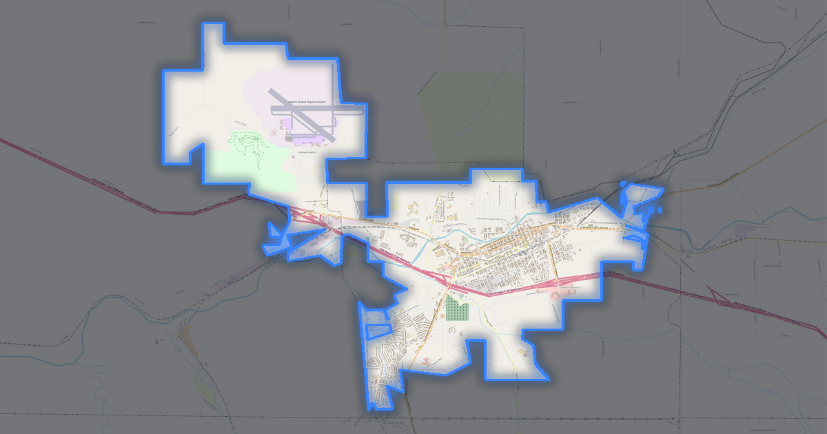
Isi peta Gresham
Peta mencakup seluruh wilayah Gresham dalam batas administratif — 61 km2. Ruang hijau menempati 19% wilayah. Setiap lapisan dapat dihidupkan atau dimatikan sebelum diunduh.
Tampilan peta Gresham
Tempat yang sama dalam tiga gaya render. Bangunan, jalan, air, dan ruang hijau dialihkan ke setiap format tanpa kehilangan kualitas.
Skor tempat
Indeks komposit dari data OpenStreetMap: seberapa nyaman tinggal di sini, berjalan kaki, menggunakan transportasi umum, dan ruang hijau.
Infrastruktur Gresham
Apa yang ada di wilayah ini menurut data OpenStreetMap.
Kepadatan dan kejenuhan
Berapa banyak objek per kilometer persegi — menurut data OpenStreetMap.
Cara peta digunakan
Kumpulan data yang sama untuk Gresham — untuk berbagai tugas: dari penggambaran hingga cetak 3D.
Landmark
Museum, monumen, dan tempat penting di Gresham menurut data OpenStreetMap — masing-masing dengan tautan ke peta.
Alam dan ruang hijau
Taman, alun-alun, dan badan air di Gresham menurut data OpenStreetMap — semuanya dialihkan ke peta sebagai lapisan terpisah.
Transportasi umum
Halte dan stasiun menurut data OpenStreetMap.
Transportasi umum di Gresham meliputi 342 halte bus, 9 stasiun kereta dan 18 halte trem. Semua halte dan stasiun disertakan dalam peta sebagai lapisan terpisah.
Jalan dan jalanan
Jalan diklasifikasikan menurut jenis — menurut data OpenStreetMap.
Jaringan jalan di Gresham — 976 km jalan menurut data OpenStreetMap, diklasifikasikan menurut jenis.
Restoran dan kafe
Tempat makan dan minum menurut data OpenStreetMap.
Di Gresham, OpenStreetMap mencatat 118 tempat makan dan minum — restoran, kafe, bar, dan gerai makanan cepat saji.
Toko dan ritel
Ritel menurut data OpenStreetMap.
Di Gresham, OpenStreetMap mencatat 118 toko dan gerai ritel. Kategori utama: Minimarket, Kecantikan, Bengkel, Dealer mobil, Pakaian, Salon rambut.
Pendidikan
Sekolah, universitas, dan perpustakaan menurut data OpenStreetMap.
Sekolah: Center for Advanced Learning, Lupine Community Montessori Charter School, Aspen Highland Elementary School, Open School East, Montessori Morningstar House of Children, Greater Portland Christian Academy. Universitas: MHCC Bruning Center for Allied Health Education.
Layanan kesehatan
Rumah sakit, apotek, dan klinik menurut data OpenStreetMap.
Tempat menginap
Hotel, hostel, dan rumah tamu menurut data OpenStreetMap.
Apa yang ada di peta
Setiap lapisan peta Gresham dapat dihidupkan atau dimatikan sebelum diunduh.
Angka-angka utama
Ringkasan berdasarkan data OpenStreetMap untuk Gresham.
Tentang Gresham
.place-narrative{margin:2rem 0;padding:2rem;background:#f8fafc;border-radius:16px} .place-narrative h2{font-size:1.5rem;margin-bottom:1rem;color:#1e293b} .place-narrative__text p{font-size:1.1rem;line-height:1.7;color:#334155;max-width:72ch} .place-narrative__strengths{margin-top:1.5rem} .place-narrative__strengths h3{font-size:1.15rem;margin-bottom:.8rem;color:#1e293b} .place-narrative__strength-grid{display:grid;grid-template-columns:repeat(auto-fit,minmax(220px,1fr));gap:1rem} .place-narrative__strength{padding:1rem;background:#fff;border-radius:12px;border:1px solid #e2e8f0} .strength-score{font-size:1.5rem;font-weight:700;color:#10b981} .place-narrative__strength strong{display:block;margin:.4rem 0 .2rem;color:#1e293b} .place-narrative__strength p{font-size:.9rem;color:#64748b;margin:0} .place-narrative__facts{margin-top:1.5rem} .place-narrative__facts h3{font-size:1.15rem;margin-bottom:.8rem;color:#1e293b} .place-narrative__fact-grid{display:grid;grid-template-columns:repeat(auto-fit,minmax(260px,1fr));gap:1rem} .place-narrative__fact{display:flex;align-items:flex-start;gap:.75rem;padding:1rem;background:#fff;border-radius:12px;border:1px solid #e2e8f0} .fact-icon{font-size:1.5rem;flex-shrink:0} .place-narrative__fact p{font-size:.95rem;color:#334155;margin:0;line-height:1.5} @media(max-width:640px){.place-narrative__strength-grid,.place-narrative__fact-grid{grid-template-columns:1fr}} Potret Analitis: Gresham Gresham membentang seluas 61.2 km² dan memuat 32,890 bangunan. Area hijau mencakup 19.0% dari kota. Jaringan transportasi umum yang luas (369 halte) memberikan mobilitas yang tinggi.
Keunggulan 85/100 Konektivitas Jaringan jalan yang sangat terhubung 62/100 Cakupan Hijau Cakupan hijau yang sedang 56/100 Pendidikan Institusi pendidikan yang memadai Fakta Menarik 🛣️ Total panjang jalan Gresham (976 km) adalah 976 km jalan. 🏗️ Terdapat 0.29 bangunan per penduduk di Gresham. 🌳 Setiap penduduk Gresham memiliki 187 m² ruang hijau.
🍽️ Gresham memiliki ~45 restoran dan kafe — 0.4 per 1.000 penduduk.
Dibandingkan dengan tetangga
Bagaimana tempat ini dibandingkan dengan tetangga dalam radius 30 kilometer.
69 tempat dalam radius 30 km untuk dibandingkan.