osm2cdr.ru
U
© OpenStreetMap
Batas · Florence · OpenStreetMap
BangunanJalanAirRuang hijauBatas
Peta siap pakai · data OSM

Peta Florence

Kota · 8K · 16 km2

Peta vektor siap pakai dengan bangunan, jalan, dan objek — untuk CAD, GIS, dan cetak. Unduh seketika, tanpa registrasi.

Pilih format
Unduh · DWG, ≈ 6.7 MB
Semua 133 format Sesuaikan area Anda
133 formatdata OSMtanpa registrasisiap seketika

Paspor peta

16 km2
Luas
5 169
Bangunan
181 km
Jalan
180
Titik menarik
Sesuaikan peta untuk Anda sendiri

Buka area Florence di konstruktor dan ubah lapisan, gaya, format, dan sistem koordinat sesuai tugas Anda.

Buka di konstruktor

Peta secara bawaan

Beginilah peta disusun secara bawaan — setiap parameter dapat diubah di konstruktor.

Format
DWG .dwgpilih
Lapisan
Jalan, Bangunan, Air, Ruang hijau, POIubah
Gaya
Standar (berwarna)ubah
Detail
otomatis · menurut ukuran areaubah
Nomor rumah
semuaubah
Titik menarik
semua kategoriubah
Sistem koordinat
WGS 84 (otomatis)ubah
Ukuran lembar
Relief dan grid
matiubah

Unduh peta Florence dalam 133 format

Kumpulan data OpenStreetMap yang sama — dalam format untuk perangkat lunak Anda. Pilih menurut tugas: CAD, vektor, GIS, 3D, atau cetak.
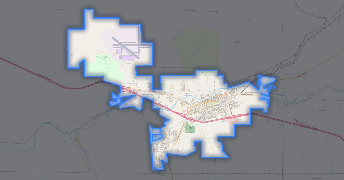
Format populerformat yang paling umum
PALING UMUM
PDFuntuk cetak dan lihat.pdf · ≈ 3.2 MB
CDRuntuk CorelDRAW.cdr · ≈ 4.8 MB
SVGuntuk Illustrator, Inkscape, web.svg · ≈ 4.8 MB
GeoJSONuntuk QGIS dan peta web.geojson · ≈ 9.6 MB
DWGuntuk AutoCAD, nanoCAD, BricsCAD.dwg · ≈ 6.7 MB
CADpenggambaran dan desain
DWGFREE
AutoCAD.dwg · ≈ 6.7 MB
DXFFREE
Pertukaran CAD.dxf · ≈ 7.2 MB
CDRFREE
CorelDRAW.cdr · ≈ 4.8 MB
DGNFREE
MicroStation.dgn · ≈ 4.8 MB
Vektorilustrasi dan web
SVGFREE
Web · vektor.svg · ≈ 4.8 MB
AIFREE
Illustrator.ai · ≈ 4 MB
EPSFREE
Produksi cetak.eps · ≈ 4 MB
PDFFREE
Vektor · cetak.pdf · ≈ 3.2 MB
GISdata bergeoreferensi
GeoJSONFREE
GIS · data.geojson · ≈ 9.6 MB
ShapefileFREE
QGIS · ArcGIS.shp · ≈ 4.8 MB
KMLFREE
Google Earth.kml · ≈ 8.6 MB
GeoPackageFREE
GeoPackage.gpkg · ≈ 5.7 MB
3Dvolume dan model
STLFREE
Cetak 3D.stl · ≈ 12 MB
OBJFREE
Model 3D.obj · ≈ 14.3 MB
glTFFREE
3D · web.gltf · ≈ 13.4 MB
DAEFREE
Collada.dae · ≈ 15.3 MB
Cetakraster dan tata letak
PNGFREE
Raster · transparansi.png · ≈ 2 MB
JPGFREE
Raster.jpg · ≈ 1.2 MB
PDFFREE
Tata letak cetak.pdf · ≈ 3.2 MB
TIFFFREE
Produksi cetak.tif · ≈ 12 MB
Buka semua 133 format

Peta Florence

Kota dan distrik terdekat — setiap peta siap diunduh.

Portland
Portland
Kota · 652K
Eugene
Eugene
Kota · 159K
Salem
Salem
Kota · 155K
Gresham
Gresham
Kota · 114K
Bend
Bend
Kota · 111K
Hillsboro
Hillsboro
Kota · 106K
Beaverton
Beaverton
Kota · 97K
Medford
Medford
Kota · 74K
Springfield
Springfield
Kota · 62K
Lane County
Lane County
Distrik · 362K
Corvallis
Corvallis
Kota · 58K
Clackamas County
Clackamas County
Distrik · 401K
Tigard
Tigard
Kota · 54K
Albany
Albany
Kota · 54K
Washington County
Washington County
Distrik · 574K
Multnomah County
Multnomah County
Distrik · 790K
Lake Oswego
Lake Oswego
Kota · 40K
Marion County
Marion County
Distrik · 330K
Oregon City
Oregon City
Kota · 37K
Keizer
Keizer
Kota · 35K
Grants Pass
Grants Pass
Kota · 34K
Redmond
Redmond
Kota · 33K
Jackson County
Jackson County
Distrik · 212K
McMinnville
McMinnville
Kota · 30K
Douglas County
Douglas County
Distrik · 107K
Tualatin
Tualatin
Kota · 28K
La Pine
La Pine
Kota
West Linn
West Linn
Kota · 27K
Wilsonville
Wilsonville
Kota · 26K
Forest Grove
Forest Grove
Kota · 26K
Newberg
Newberg
Kota · 25K
Happy Valley
Happy Valley
Kota · 23K
Woodburn
Woodburn
Kota · 22K
Klamath Falls
Klamath Falls
Kota · 21K
Linn County
Linn County
Distrik · 120K
Milwaukie
Milwaukie
Kota · 21K
Roseburg
Roseburg
Kota · 20K
Sherwood
Sherwood
Kota · 20K
Ashland
Ashland
Kota · 20K
Deschutes County
Deschutes County
Distrik · 175K
Hermiston
Hermiston
Kota · 19K
Klamath County
Klamath County
Distrik · 66K
Lebanon
Lebanon
Kota · 18K
Umatilla County
Umatilla County
Distrik · 76K
Canby
Canby
Kota · 18K
Pendleton
Pendleton
Kota · 16K
Coos Bay
Coos Bay
Kota · 16K
Troutdale
Troutdale
Kota · 16K
Central Point
Central Point
Kota · 16K
Coos County
Coos County
Distrik · 63K
Josephine County
Josephine County
Distrik · 84K
Brookings
Brookings
Kota
Dallas
Dallas
Kota · 14K
The Dalles
The Dalles
Kota · 13K
Yamhill County
Yamhill County
Distrik · 102K
La Grande
La Grande
Kota · 13K
Saint Helens
Saint Helens
Kota · 12K
Cornelius
Cornelius
Kota · 12K
Sandy
Sandy
Kota · 12K
Polk County
Polk County
Distrik · 79K
Gladstone
Gladstone
Kota · 12K
Malheur County
Malheur County
Distrik · 30K
Lincoln County
Lincoln County
Distrik · 47K
Benton County
Benton County
Distrik · 87K
Ontario
Ontario
Kota · 11K
Cottage Grove
Cottage Grove
Kota · 10K
Fairview
Fairview
Kota · 10K
Columbia County
Columbia County
Distrik · 49K
Newport
Newport
Kota · 9K
North Bend
North Bend
Kota · 9K
Baker City
Baker City
Kota · 9K
Monmouth
Monmouth
Kota · 9K
Astoria
Astoria
Kota · 9K
Prineville
Prineville
Kota · 9K
Neskowin
Neskowin
Kota
Silverton
Silverton
Kota · 8K
Clatsop County
Clatsop County
Distrik · 37K
Independence
Independence
Kota · 8K
Sweet Home
Sweet Home
Kota · 8K
Molalla
Molalla
Kota · 8K
Stayton
Stayton
Kota · 8K
Eagle Point
Eagle Point
Kota · 7K
Lincoln City
Lincoln City
Kota · 7K
Tillamook County
Tillamook County
Distrik · 25K
Wasco County
Wasco County
Distrik · 25K
Umatilla
Umatilla
Kota · 7K
Sutherlin
Sutherlin
Kota · 7K
Baker County
Baker County
Distrik · 16K
Junction City
Junction City
Kota · 6K
Hood River
Hood River
Kota · 6K
Scappoose
Scappoose
Kota · 6K
Milton-Freewater
Milton-Freewater
Kota · 6K
Madras
Madras
Kota · 6K
Union County
Union County
Distrik · 25K
Seaside
Seaside
Kota · 6K
Talent
Talent
Kota · 6K
Pacific City
Pacific City
Kota
Curry County
Curry County
Distrik · 22K
Nyssa
Nyssa
Kota
Sheridan
Sheridan
Kota · 5K
Philomath
Philomath
Kota · 5K
King City
King City
Kota · 5K
Jefferson County
Jefferson County
Distrik · 22K
Heppner
Heppner
Kota
Winston
Winston
Kota · 4K
Creswell
Creswell
Kota · 4K
Wood Village
Wood Village
Kota · 4K
Phoenix
Phoenix
Kota · 4K
Crook County
Crook County
Distrik · 21K
Tillamook
Tillamook
Kota · 4K
Warrenton
Warrenton
Kota · 4K
Lancaster
Lancaster
Kota
Reedsport
Reedsport
Kota · 4K
Lafayette
Lafayette
Kota · 4K
Coquille
Coquille
Kota · 4K
Boardman
Boardman
Kota · 3K
Veneta
Veneta
Kota · 3K
Cheshire
Cheshire
Kota
Hood River County
Hood River County
Distrik · 23K
Harrisburg
Harrisburg
Kota · 3K
Myrtle Creek
Myrtle Creek
Kota · 3K
Estacada
Estacada
Kota · 3K
North Plains
North Plains
Kota · 3K
Toledo
Toledo
Kota · 3K
Mount Angel
Mount Angel
Kota · 3K
Aumsville
Aumsville
Kota · 3K
Elmira
Elmira
Kota
Idanha
Idanha
Kota
Oakridge
Oakridge
Kota · 3K
Sisters
Sisters
Kota · 3K
Dundee
Dundee
Kota · 3K
Sublimity
Sublimity
Kota · 2K
Bandon
Bandon
Kota · 2K
Jacksonville
Jacksonville
Kota · 2K
Burns
Burns
Kota · 2K
Jefferson
Jefferson
Kota · 2K
Altamont
Altamont
Kota · 19K
Hubbard
Hubbard
Kota · 2K
Myrtle Point
Myrtle Point
Kota · 2K
Lakeview
Lakeview
Kota · 2K
Gervais
Gervais
Kota · 2K
Gates
Gates
Kota
Shady Cove
Shady Cove
Kota · 2K
Willamina
Willamina
Kota · 2K
Dayton
Dayton
Kota · 2K
Vernonia
Vernonia
Kota · 2K
Carlton
Carlton
Kota · 2K
Stanfield
Stanfield
Kota · 2K
Waldport
Waldport
Kota · 2K
Irrigon
Irrigon
Kota · 2K
Durham
Durham
Kota · 1K
Enterprise
Enterprise
Kota · 1K
Rogue River
Rogue River
Kota · 1K
Union
Union
Kota · 1K
Vale
Vale
Kota · 1K
Columbia City
Columbia City
Kota · 1K
Gold Beach
Gold Beach
Kota · 1K
Mill City
Mill City
Kota · 1K
Rainier
Rainier
Kota · 1K
Amity
Amity
Kota · 1K
Cannon Beach
Cannon Beach
Kota · 1K
Elgin
Elgin
Kota · 1K
John Day
John Day
Kota · 1K
Clatskanie
Clatskanie
Kota · 1K
Turner
Turner
Kota · 1K
Brownsville
Brownsville
Kota · 1K
Banks
Banks
Kota · 1K
Pilot Rock
Pilot Rock
Kota · 1K
Hines
Hines
Kota · 1K
Lakeside
Lakeside
Kota · 1K
Canyonville
Canyonville
Kota · 1K
Cave Junction
Cave Junction
Kota · 1K
Depoe Bay
Depoe Bay
Kota · 1K
Rockaway Beach
Rockaway Beach
Kota · 1K
Dunes City
Dunes City
Kota · 1K
Athena
Athena
Kota · 1K
Port Orford
Port Orford
Kota · 1K
Bay City
Bay City
Kota · 1K
Joseph
Joseph
Kota · 1K
Yamhill
Yamhill
Kota · 1K
Siletz
Siletz
Kota · 1K
Cascade Locks
Cascade Locks
Kota · 1K
Gearhart
Gearhart
Kota · 1K
Lyons
Lyons
Kota · 1K
St. Paul
St. Paul
Kota
Yoncalla
Yoncalla
Kota · 1K
Gold Hill
Gold Hill
Kota · 1K
Drain
Drain
Kota · 1K
Falls City
Falls City
Kota · 1K
Culver
Culver
Kota · 1K
Riddle
Riddle
Kota · 1K
Coburg
Coburg
Kota · 1K
Tangent
Tangent
Kota · 980
Aurora
Aurora
Kota · 966
Prairie City
Prairie City
Kota · 952
Lowell
Lowell
Kota · 948
Adrian
Adrian
Kota
Oakland
Oakland
Kota · 927
Garibaldi
Garibaldi
Kota · 917
Island City
Island City
Kota · 902
Glendale
Glendale
Kota · 899
Merrill
Merrill
Kota · 893
Maywood Park
Maywood Park
Kota · 822
Wallowa
Wallowa
Kota · 796
Halsey
Halsey
Kota · 782
Gaston
Gaston
Kota · 776
Powers
Powers
Kota · 752
Metolius
Metolius
Kota · 737
Chiloquin
Chiloquin
Kota · 734
Scio
Scio
Kota · 712
Weston
Weston
Kota · 709
Condon
Condon
Kota · 693
Echo
Echo
Kota · 684
Yachats
Yachats
Kota · 683
Johnson City
Johnson City
Kota · 668
Millersburg
Millersburg
Kota · 661
Monroe
Monroe
Kota · 647
Donald
Donald
Kota · 643
Malin
Malin
Kota · 635
Manzanita
Manzanita
Kota · 630
Cove
Cove
Kota · 600
Canyon City
Canyon City
Kota · 587
Arlington
Arlington
Kota · 586
Dufur
Dufur
Kota · 584
Adair Village
Adair Village
Kota · 548
Rivergrove
Rivergrove
Kota · 542
Mount Vernon
Mount Vernon
Kota · 524
Huntington
Huntington
Kota · 502
North Powder
North Powder
Kota · 481
Butte Falls
Butte Falls
Kota · 429
Maupin
Maupin
Kota · 418
Bonanza
Bonanza
Kota · 415
Fossil
Fossil
Kota · 413
Mosier
Mosier
Kota · 410
Haines
Haines
Kota · 400
Wheeler
Wheeler
Kota · 396
Halfway
Halfway
Kota · 351
Greenhorn
Greenhorn
Kota
Ione
Ione
Kota · 334
Scotts Mills
Scotts Mills
Kota · 332
Wasco
Wasco
Kota · 329
Adams
Adams
Kota · 295
Sodaville
Sodaville
Kota · 292
Moro
Moro
Kota · 291
Lexington
Lexington
Kota · 275
Westfir
Westfir
Kota · 275
Detroit
Detroit
Kota · 270
Ukiah
Ukiah
Kota · 254
Malabon
Malabon
Kota · 250
Imbler
Imbler
Kota · 245
Paisley
Paisley
Kota · 245
Lostine
Lostine
Kota · 241
Waterloo
Waterloo
Kota · 241
Rufus
Rufus
Kota · 229
Nehalem
Nehalem
Kota · 208
Long Creek
Long Creek
Kota · 199
Seneca
Seneca
Kota · 195
Helix
Helix
Kota · 182
Sunriver
Sunriver
Kota · 1K
Richland
Richland
Kota · 165
Sumpter
Sumpter
Kota · 160
Elkton
Elkton
Kota · 150
Mitchell
Mitchell
Kota · 149
Grass Valley
Grass Valley
Kota · 147
Barlow
Barlow
Kota · 144
Monument
Monument
Kota · 132
Jordan Valley
Jordan Valley
Kota · 130
Spray
Spray
Kota · 124
Unity
Unity
Kota · 123
Dayville
Dayville
Kota · 120
Summerville
Summerville
Kota · 119
Prescott
Prescott
Kota · 74
Antelope
Antelope
Kota · 46
Shaniko
Shaniko
Kota · 26
Lonerock
Lonerock
Kota · 25
Granite
Granite
Kota · 21
Harney County
Harney County
Distrik
Lake County
Lake County
Distrik
Grant County
Grant County
Distrik
Morrow County
Morrow County
Distrik
Wallowa County
Wallowa County
Distrik
Wheeler County
Wheeler County
Distrik
Sherman County
Sherman County
Distrik
Gilliam County
Gilliam County
Distrik

Tempat dan region tetangga

Telusuri ke kota, distrik, dan region tetangga — masing-masing memiliki peta vektor siap pakai dalam format yang sama.

Wilayah United States

California39 576 757Texas29 145 505New York20 201 249Pennsylvania13 078 751Illinois12 812 508Ohio11 883 304Georgia11 180 878North Carolina11 046 024Michigan10 140 459Tennessee7 227 750Indiana6 924 275Missouri6 245 466Wisconsin5 960 975Colorado5 957 493Minnesota5 793 151Alabama5 024 279Louisiana4 597 740Kentucky4 588 372Oklahoma3 963 516Iowa3 241 488Arkansas3 088 354Kansas2 970 606Nebraska2 005 465Maine1 405 012Virginia8 811 195Washington7 958 180Mississippi2 943 045South Carolina5 478 831South Dakota924 669Utah3 503 613
United States — semua wilayah

Terdekat

Oregon4 272 371 · 281 km · WilayahSeattle737 015 · 425 km · KotaJuan de Fuca Electoral Area495 km · KotaTacoma219 346 · 383 km · KotaVancouver190 915 · 217 km · Kota

Kota serupa di seluruh dunia

Santa Bárbara do Sul8 122Sérignan8 123Námestovo8 123Rheinsberg8 120Souffelweyersheim8 120Ain Dorbane8 120
5 169bangunan
181 kmjalan dan jalanan
180objek
133format
WGS 84sistem koordinat

Isi peta Florence

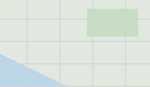
Peta mencakup seluruh wilayah Florence dalam batas administratif — 16 km2. Ruang hijau menempati 16.4% wilayah. Setiap lapisan dapat dihidupkan atau dimatikan sebelum diunduh.

5 169bangunan
Bangunan pada lapisan terpisah
permukiman59
komersial34
industri1
181km
Jalan dengan klasifikasi
магистрали12 km
проезды44 km
велодорожки1 km
180POI
Titik menarik
банки7
кафе6
заправки8
Jalan utama
North Fork Siuslaw RoadKingwood StreetNorth Rhododendron DriveRhododendron DriveHeceta Beach RoadSpruce Street
Landmark · 6
Oregon Coast Military Museum
Siuslaw Pioneer Museum
C.R.O.W. Center for the Performing Arts
The River Gallery
The Laughing Crab Gallery & Tasting Room
Artiques

Tampilan peta Florence

Tempat yang sama dalam tiga gaya render. Bangunan, jalan, air, dan ruang hijau dialihkan ke setiap format tanpa kehilangan kualitas.

Cetak biru (CAD) — peta Florence
Cetak biru (CAD)
Garis tepi pada latar gelap — untuk DWG dan DXF
Vektor standar — peta Florence
Vektor standar
Peta berwarna dengan bangunan, jalan, dan ruang hijau
Tata letak cetak — peta Florence
Tata letak cetak
Tata letak siap pakai untuk PDF dan produksi cetak

Skor tempat

Indeks komposit dari data OpenStreetMap: seberapa nyaman tinggal di sini, berjalan kaki, menggunakan transportasi umum, dan ruang hijau.

Kelayakan huni
18Masih bisa tumbuh
Indeks komposit dari 100
Keterjangkauan jalan kaki
23/100
Berkembang
Ruang hijau
36/100
Berkembang
Keamanan
4/100
Masih bisa tumbuh
Layanan kesehatan
14/100
Masih bisa tumbuh
Perdagangan
29/100
Berkembang
Budaya
4/100
Masih bisa tumbuh
Konektivitas
68/100
Baik

Infrastruktur Florence

Apa yang ada di wilayah ini menurut data OpenStreetMap.

41
Tempat makan
73
Toko
12
Hotel
1
Transportasi
7
Taman
2
Air

Kepadatan dan kejenuhan

Berapa banyak objek per kilometer persegi — menurut data OpenStreetMap.

324
bgn/km²
11,3
km/km²
11
POI/km²
16,4%
ruang hijau

Cara peta digunakan

Kumpulan data yang sama untuk Florence — untuk berbagai tugas: dari penggambaran hingga cetak 3D.

Arsitektur dan desain
Underlay dan garis tepi bangunan untuk gambar dan tata letak.
DWG / DXF
Desain dan ilustrasi
Dasar peta vektor untuk poster, skema, dan desain identitas.
SVG / AI
GIS dan analisis
Lapisan bergeoreferensi untuk QGIS, ArcGIS, dan analisis spasial.
GeoJSON / SHP
Cetak 3D dan model
Relief bangunan dan medan untuk pencetakan dan visualisasi.
STL
Navigasi dan jejak
Data peta untuk navigator dan aplikasi rute.
Garmin
Cetak dan penerbitan
Tata letak peta siap pakai untuk produksi cetak.
PDF

Landmark

Museum, monumen, dan tempat penting di Florence menurut data OpenStreetMap — masing-masing dengan tautan ke peta.

🏛️
Oregon Coast Military Museum
MuseumOSM
🏛️
Siuslaw Pioneer Museum
MuseumOSM
🎭
C.R.O.W. Center for the Performing Arts
TeaterOSM
🎨
The River Gallery
GaleriOSM
🎨
The Laughing Crab Gallery & Tasting Room
GaleriOSM
🎨
Artiques
GaleriOSM
🎬
City Lights Cinema
BioskopOSM
First Baptist Church
Tempat ibadahOSM
Florence Seventh-day Adventist Church
Tempat ibadahOSM
Community Baptist Church
Tempat ibadahOSM
Presbyterian Community Church of the Siuslaw
Tempat ibadahOSM
Florence Foursquare Church
Tempat ibadahOSM

Alam dan ruang hijau

Taman, alun-alun, dan badan air di Florence menurut data OpenStreetMap — semuanya dialihkan ke peta sebagai lapisan terpisah.

5,8
km² ruang hijau
16,4%
cakupan hijau
7
taman
2
badan air
Taman dan alun-alun
North Jetty Park · 101 ha
Miller Park · 9 ha
Singing Pines Park · 2 ha
Exploding Whale Memorial Park · 1 ha
Heceta Beach County Park · 1 ha
Badan air
Siuslaw River · sungai
Munsel Creek · anak sungai

Transportasi umum

Halte dan stasiun menurut data OpenStreetMap.

1
halte bus

Transportasi umum di Florence meliputi 1 halte bus. Semua halte dan stasiun disertakan dalam peta sebagai lapisan terpisah.

Jalan dan jalanan

Jalan diklasifikasikan menurut jenis — menurut data OpenStreetMap.

77,8 km
улицы и проезды
44 km
проезды
29,2 km
дороги местного значения
12,6 km
дороги областного значения
12,2 km
магистрали
3,2 km
прочие дороги
1,8 km
велодорожки
0,1 km
жилые зоны

Jaringan jalan di Florence — 181 km jalan menurut data OpenStreetMap, diklasifikasikan menurut jenis.

Jalan bernama
North Fork Siuslaw Road · 8,3 km
Kingwood Street · 3,5 km
North Rhododendron Drive · 3,4 km
Rhododendron Drive · 3,3 km
Heceta Beach Road · 3 km
Spruce Street · 2,9 km
Munsel Lake Road · 2,7 km
Oak Street · 2,4 km

Restoran dan kafe

Tempat makan dan minum menurut data OpenStreetMap.

24
restoran
6
kafe
2
bar
9
makanan cepat saji

Di Florence, OpenStreetMap mencatat 41 tempat makan dan minum — restoran, kafe, bar, dan gerai makanan cepat saji.

Tempat terkenal
Waterfront Depot Restaurant
Bridgewater Restaurant
Restobar
Mari's Kitchen
Nosh Eatery
Krab Kettle
Homegrown Public House
Little Brown Hen Cafe

Toko dan ritel

Ritel menurut data OpenStreetMap.

73
toko

Di Florence, OpenStreetMap mencatat 73 toko dan gerai ritel. Kategori utama: Minimarket, Furnitur, Storage Rental, Antiques, Bahan bangunan, Suku cadang.

Minimarket5Furnitur4Storage Rental4Antiques3Bahan bangunan3Suku cadang3Supermarket3Pet Grooming3Hadiah2Mal2

Pendidikan

Sekolah, universitas, dan perpustakaan menurut data OpenStreetMap.

7
sekolah
1
universitas
1
perpustakaan

Sekolah: Shoreline Christian School, Siuslaw Elementary School, Siuslaw High School, Siuslaw Middle School. Universitas: Lane Community College - Florence. Perpustakaan: Siuslaw Public Library.

Layanan kesehatan

Rumah sakit, apotek, dan klinik menurut data OpenStreetMap.

1
rumah sakit
4
apotek
3
klinik

Rumah sakit di Florence: PeaceHealth Peace Harbor Medical Center.

Tempat menginap

Hotel, hostel, dan rumah tamu menurut data OpenStreetMap.

12
tempat menginap
Hotel dan rumah tamu
Edwin K Bed & Breakfast · Rumah tamu
Harbor Vista County Campground & Park
Driftwood Shores Inn · Hotel
Quality Inn · Hotel
Silver Sands Motel · Motel
Le Chateau Inn · Hotel
Villa West Motel · Motel
Economy Inn · Motel

Apa yang ada di peta

Setiap lapisan peta Florence dapat dihidupkan atau dimatikan sebelum diunduh.

Lapisan peta
Bangunan: 5 169
Jalan: 181 km
Titik menarik: 180
Ruang hijau: 5,8 km²

Angka-angka utama

Ringkasan berdasarkan data OpenStreetMap untuk Florence.

Bangunan5 169
Bangunan permukiman59
Bangunan komersial34
Jalan181 km
Ruang hijau5,8 km²
Cakupan hijau16,4%
Tempat makan dan minum41
Toko73
Titik menarik180
Halte bus1
Rumah sakit1
Apotek4
Landmark12

Tentang Florence

.place-narrative{margin:2rem 0;padding:2rem;background:#f8fafc;border-radius:16px} .place-narrative h2{font-size:1.5rem;margin-bottom:1rem;color:#1e293b} .place-narrative__text p{font-size:1.1rem;line-height:1.7;color:#334155;max-width:72ch} .place-narrative__strengths{margin-top:1.5rem} .place-narrative__strengths h3{font-size:1.15rem;margin-bottom:.8rem;color:#1e293b} .place-narrative__strength-grid{display:grid;grid-template-columns:repeat(auto-fit,minmax(220px,1fr));gap:1rem} .place-narrative__strength{padding:1rem;background:#fff;border-radius:12px;border:1px solid #e2e8f0} .strength-score{font-size:1.5rem;font-weight:700;color:#10b981} .place-narrative__strength strong{display:block;margin:.4rem 0 .2rem;color:#1e293b} .place-narrative__strength p{font-size:.9rem;color:#64748b;margin:0} .place-narrative__facts{margin-top:1.5rem} .place-narrative__facts h3{font-size:1.15rem;margin-bottom:.8rem;color:#1e293b} .place-narrative__fact-grid{display:grid;grid-template-columns:repeat(auto-fit,minmax(260px,1fr));gap:1rem} .place-narrative__fact{display:flex;align-items:flex-start;gap:.75rem;padding:1rem;background:#fff;border-radius:12px;border:1px solid #e2e8f0} .fact-icon{font-size:1.5rem;flex-shrink:0} .place-narrative__fact p{font-size:.95rem;color:#334155;margin:0;line-height:1.5} @media(max-width:640px){.place-narrative__strength-grid,.place-narrative__fact-grid{grid-template-columns:1fr}} Potret Analitis: Florence Florence membentang seluas 15.9 km² dan memuat 5,169 bangunan. Area hijau mencakup 16.4% dari kota. Keunggulan 68/100 Konektivitas Konektivitas jaringan jalan rata-rata 36/100 Cakupan Hijau Cakupan hijau yang tidak memadai 29/100 Perdagangan Infrastruktur komersial yang terbatas Fakta Menarik 🛣️ Total panjang jalan Florence (180 km) adalah 180 km jalan.

🏗️ Terdapat 0.64 bangunan per penduduk di Florence. 🌳 Setiap penduduk Florence memiliki 714 m² ruang hijau. 🍽️ Florence memiliki ~27 restoran dan kafe — 3.3 per 1.000 penduduk.

Dibandingkan dengan tetangga

Bagaimana tempat ini dibandingkan dengan tetangga dalam radius 30 kilometer.

18 tempat dalam radius 30 km untuk dibandingkan.

🏠 Built-uppercentile 94 of 100
🛣️ Roadspercentile 28 of 100

Pertanyaan yang sering diajukan

Buka osm2cdr.ru, pilih area target di peta, pilih format, dan mulai ekspor. Sebagian besar peta siap dalam 1-5 menit.
Peta Florence tersedia dalam 133 format: CDR, DWG, DXF, SVG, AI, EPS, PDF, PNG, GeoJSON, KML, Shapefile, GeoTIFF, dan lainnya.
Ya! Peta lengkap Florence dapat diekspor gratis selama Open Beta — semua 133 format, tanpa batas luas area, tanpa registrasi.
Layanan ini menggunakan data OpenStreetMap yang diperbarui secara berkala.
Untuk "kota" biasanya 1-3 menit, dan hingga 10 menit untuk wilayah besar.