osm2cdr.ru
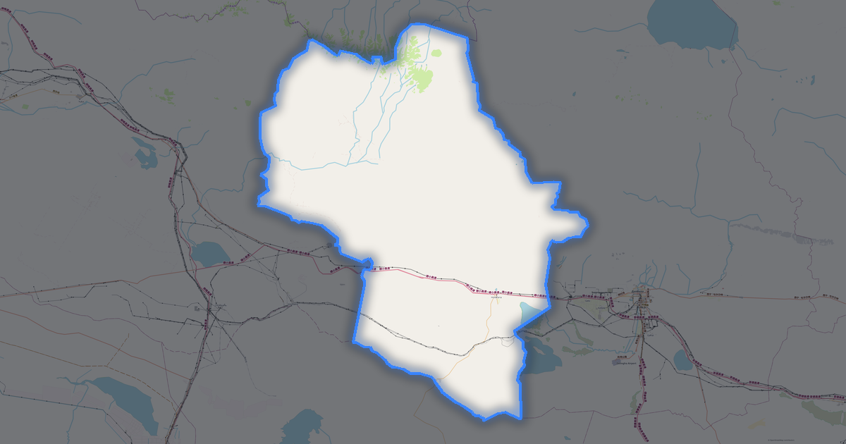
Map of Haixi Mongol and Tibetan Autonomous Prefecture
Haixi Mongol and Tibetan Autonomous Prefecture
Qinghai · 468K
N
© OpenStreetMap
Boundary · Qinghai · OpenStreetMap
BuildingsRoadsWaterGreeneryBoundary
Ready map · OSM data

Map of Haixi Mongol and Tibetan Autonomous Prefecture

District · Qinghai · 468K · 255,128 km2

A ready-made vector map with buildings, roads and features — for CAD, GIS and print. Instant download, no registration.

Choose a format
Download · PDF, ≈ 9.1 MB
All 133 formats Customize your area
133 formatsOSM datano registrationready instantly

Map passport

255,128 km2
Area
9 383
Buildings
19 590 km
Roads
905
Points of interest
Customize the map for yourself

Open the area of Haixi Mongol and Tibetan Autonomous Prefecture in the constructor and change layers, style, format and coordinate system for your task.

Open in constructor

Map defaults

This is how the map is built by default — every parameter can be changed in the constructor.

Format
PDF .pdfchoose
Layers
Roads, Buildings, Water, Greenery, POIchange
Style
Standard (colour)change
Detail
overview (auto)change
House numbers
not visible at this scalechange
Points of interest
not visible at this scalechange
Coordinate system
WGS 84 (auto)change
Sheet size
Relief and grid

Download the map of Haixi Mongol and Tibetan Autonomous Prefecture in 133 formats

The same OpenStreetMap dataset — in the format for your software. Pick by task: CAD, vector, GIS, 3D or print.

Popular formatsthe most common formats
MOST COMMON
PDFfor printing and viewing.pdf · ≈ 10.2 MB
CDRfor CorelDRAW.cdr · ≈ 1.6 MB
SVGfor Illustrator, Inkscape, web.svg · ≈ 12 MB
GeoJSONfor QGIS and web maps.geojson · ≈ 15.3 MB
DWGfor AutoCAD, nanoCAD, BricsCAD.dwg · ≈ 4.4 MB
CADdrafting and design
DWGFREE
AutoCAD.dwg · ≈ 3.9 MB
DXFFREE
CAD exchange.dxf · ≈ 32.6 MB
CDRFREE
CorelDRAW.cdr · ≈ 1.4 MB
DGNFREE
MicroStation.dgn · ≈ 6.2 MB
Vectorillustration and web
SVGFREE
Web · vector.svg · ≈ 10.6 MB
AIFREE
Illustrator.ai · ≈ 8.7 MB
EPSFREE
Print production.eps · ≈ 8.5 MB
PDFFREE
Vector · print.pdf · ≈ 9.1 MB
GISgeo-referenced data
GeoJSONFREE
GIS · data.geojson · ≈ 13.6 MB
ShapefileFREE
QGIS · ArcGIS.shp · ≈ 1.7 MB
KMLFREE
Google Earth.kml · ≈ 13.1 MB
GeoPackageFREE
GeoPackage.gpkg · ≈ 7.5 MB
3Dvolume and models
STLFREE
3D printing.stl · ≈ 609 KB
OBJFREE
3D model.obj · ≈ 237 KB
glTFFREE
3D · web.gltf · ≈ 440 KB
DAEFREE
Collada.dae · ≈ 406 KB
Printraster and layouts
PNGFREE
Raster · transparency.png · ≈ 7.1 MB
JPGFREE
Raster.jpg · ≈ 1.8 MB
PDFFREE
Print layout.pdf · ≈ 9.1 MB
TIFFFREE
Print production.tif · ≈ 16.9 MB
Open all 133 formats

Maps of Qinghai

All places within the territory — every map is ready to download.

Major cities · 48

Cities · 56

Villages and settlements · 117

Ahandalai
Ahandalai
Village
Aili Sitai
Aili Sitai
Village
Ankang
Ankang
Village
Bayin
Bayin
Village
Dari Demu
Dari Demu
Village
Dongshangen
Dongshangen
Village
Gahe
Gahe
Village
Gasi
Gasi
Village
Gebi
Gebi
Village
Guanjiaoyahe
Guanjiaoyahe
Village
Guolimu
Guolimu
Village
Halatuo Luohai
Halatuo Luohai
Village
Hebei
Hebei
Village
Jinshuikou
Jinshuikou
Village
Nuomuhong
Nuomuhong
Village
Saishitang
Saishitang
Village
Serh
Serh
Village
Shali Kete
Shali Kete
Village
Shangchaikai
Shangchaikai
Village
Shari
Shari
Village
Siyuan
Siyuan
Village
Sizhan
Sizhan
Village
Tempong
Tempong
Village
Tuolahai
Tuolahai
Village
Wudadui Sanzhongdui
Wudadui Sanzhongdui
Village
Wushisan Daoban
Wushisan Daoban
Village
Xiachaikai
Xiachaikai
Village
Xiaozaohuo
Xiaozaohuo
Village
Xiaxitai
Xiaxitai
Village
Xingfu
Xingfu
Village
Yidadui
Yidadui
Village
Yidadui Qingniandui
Yidadui Qingniandui
Village
Yidadui Sanzhongdui
Yidadui Sanzhongdui
Village
Yinmaxia
Yinmaxia
Village
Yuka
Yuka
Village
Zhamari
Zhamari
Village
Zhigari
Zhigari
Village
Zhongzhuang
Zhongzhuang
Village
下滩村
下滩村
Village
中源村
中源村
Village
乐苑村
乐苑村
Village
伊克高里
伊克高里
Village
众祥村
众祥村
Village
先锋村
先锋村
Village
努日巴村
努日巴村
Village
和谐村
和谐村
Village
城北村
城北村
Village
夏塔拉村
夏塔拉村
Village
多尔玛村
多尔玛村
Village
孟克台村
孟克台村
Village
宝库村
宝库村
Village
富源村
富源村
Village
小夏滩村
小夏滩村
Village
小岛村
小岛村
Village
建筑遗址?
建筑遗址?
Village
托托村
托托村
Village
托海村
托海村
Village
拉智村
拉智村
Village
拖拉海村
拖拉海村
Village
措里玛村
措里玛村
Village
新乐村
新乐村
Village
新华村
新华村
Village
智益
智益
Village
果米村
果米村
Village
查查村
查查村
Village
查那村
查那村
Village
格日罗村
格日罗村
Village
民康村
民康村
Village
沙珠玉村
沙珠玉村
Village
河西村
河西村
Village
涩北气田
涩北气田
Village
清水河村
清水河村
Village
盐桥村
盐桥村
Village
祥和村
祥和村
Village
秀沟村
秀沟村
Village
科尔
科尔
Village
红柳村
红柳村
Village
纳赤台
纳赤台
Village
联合村
联合村
Village
胡杨城镇社区
胡杨城镇社区
Village
菊花村
菊花村
Village
西大滩
西大滩
Village
要盖村
要盖村
Village
诺木洪村
诺木洪村
Village
长江源村
长江源村
Village
阿拉尔村
阿拉尔村
Village
鱼水河村
鱼水河村
Village
黄河源昆仑社区
黄河源昆仑社区
Village
龙羊村
龙羊村
Village
东庄村
东庄村
Village
Tuanjie
Tuanjie
Village
新庄村
新庄村
Village
Henan
Henan
Village
Xitai
Xitai
Village
Mahai
Mahai
Village
Ganggan
Ganggan
Village
Kangyur
Kangyur
Village
Nanbaxian
Nanbaxian
Village
Qingshuiquan
Qingshuiquan
Village
Sebei
Sebei
Village
东山村
东山村
Village
哈区农一队
哈区农一队
Village
哈区农三队
哈区农三队
Village
巴乐格图
巴乐格图
Village
布拉村
布拉村
Village
拉陇村
拉陇村
Village
柴开
柴开
Village
狭丘旁
狭丘旁
Village
红光村
红光村
Village
茶汗诺村
茶汗诺村
Village
西王母石室
西王母石室
Village
那棱格勒
那棱格勒
Village
Dongcun
Dongcun
Village
中村
中村
Village
察汗乌苏
察汗乌苏
Village
河北村
河北村
Village
西村
西村
Village

Neighbouring places and regions

Browse to neighbouring cities, districts and regions — each has a ready-made vector map in the same formats.

Other places in Qinghai

HaidongYushu425 199Xining City2 467 965Huangnan276 215Golog215 573HaibeiHainan
All places in Qinghai

Regions of China

ZangqinggongyeyuanxiangHong KongAnhuiChongqingFujianGansuGuangdongGuangxiGuizhouHainanHebeiHeilongjiangHenanHubeiHunanInner MongoliaJiangsuJiangxiJilinLiaoningNingxiaShaanxiShandongShanxiSichuanTibetXinjiangYunnanZhejiangShanghai
China — all regions

Nearby

Jiuquan1 114 800 · 474 km · CityGolmud66 km · City

Similar cities worldwide

Onondaga County468 463Kadıköy467 919Polk County467 711Faro467 475Mandaluyong465 902Hampden County470 690
9 383buildings
19 590 kmroads and streets
905features
133formats
WGS 84coordinate system

What's inside the map of Haixi Mongol and Tibetan Autonomous Prefecture

The map covers the entire area of Haixi Mongol and Tibetan Autonomous Prefecture within administrative boundaries — 255,128 km2. Green areas cover 30.4% of the territory. Each layer can be turned on or off before download.

9 383buildings
Buildings on separate layers
residential154
commercial13
industrial23
19 590km
Roads with classification
unclassified roads6 443 km
trunk roads3 535 km
motorways3 502 km
905POI
Points of interest
sports pitches326
fuel stations142
parks61
Main streets
塔肯公路火星一号公路旧S303西莎线滨河路棉城路
Landmarks · 6
都兰县博物馆
茫崖艾肯泉
茫崖翡翠湖
昆仑圣泉
察尔汗盐湖景区
Alien Ruins

What the map of Haixi Mongol and Tibetan Autonomous Prefecture looks like

The same place in three render styles. Buildings, roads, water and greenery carry over into every format losslessly.

Blueprint (CAD) — map of Haixi Mongol and Tibetan Autonomous Prefecture
Blueprint (CAD)
Outlines on a dark background — for DWG and DXF
Standard vector — map of Haixi Mongol and Tibetan Autonomous Prefecture
Standard vector
A colour map with buildings, roads and greenery
Print layout — map of Haixi Mongol and Tibetan Autonomous Prefecture
Print layout
A ready layout for PDF and print production

Place scores

Composite indices from OpenStreetMap data: how comfortable it is to live here, walk, use transit and greenery.

Connectivity
5/100
Room to grow

Infrastructure of Haixi Mongol and Tibetan Autonomous Prefecture

What's on the territory according to OpenStreetMap data.

24
Dining
35
Shops
52
Hotels
153
Transport
16
Parks
99
Water

Density and saturation

How many features there are per square kilometre — according to OpenStreetMap data.

0
bld/km²
0,1
km/km²
0
POI/km²
30,4%
greenery

How the map is used

The same dataset for Haixi Mongol and Tibetan Autonomous Prefecture — for different tasks: from drafting to 3D printing.

Architecture and design
An underlay and building outlines for drawings and layouts.
DWG / DXF
Design and illustration
A vector map base for posters, schemes and identity design.
SVG / AI
GIS and analysis
Geo-referenced layers for QGIS, ArcGIS and spatial analysis.
GeoJSON / SHP
3D printing and models
Relief of buildings and terrain for printing and visualization.
STL
Navigation and tracks
Map data for navigators and route apps.
Garmin
Print and publishing
A ready map layout for print production.
PDF

Landmarks

Museums, monuments and notable places of Haixi Mongol and Tibetan Autonomous Prefecture according to OpenStreetMap data — each with a link to the map.

🏛️
都兰县博物馆
MuseumOSM
茫崖艾肯泉
AttractionOSM
茫崖翡翠湖
AttractionOSM
昆仑圣泉
AttractionOSM
察尔汗盐湖景区
AttractionOSM
Alien Ruins
AttractionOSM
火星湖
AttractionOSM
冷湖石油工业五号遗址
AttractionOSM
冷湖天文观测基地
AttractionOSM
冷湖石油工业遗址
AttractionOSM
俄博梁雅丹
AttractionOSM
U型公路
AttractionOSM
庆华广场
AttractionOSM
野牛沟沼泽
AttractionOSM
黑独山胭脂山景区
AttractionOSM
冷湖石油基地遗址
AttractionOSM
西王母瑶池
AttractionOSM
雅丹之眼
AttractionOSM
🗿
冷湖地中四井
MonumentOSM
🏔️
察尔汗盐湖中心码头观景台
ViewpointOSM
🏔️
玉虚峰祭台
ViewpointOSM
🏔️
拜山台
ViewpointOSM
🏔️
黑独山
ViewpointOSM
🏔️
天空之镜体验区
ViewpointOSM

Nature and green areas

Parks, squares and water bodies of Haixi Mongol and Tibetan Autonomous Prefecture according to OpenStreetMap data — everything is carried into the map as separate layers.

155312,2
km² of greenery
30,4%
green coverage
16
parks
99
water bodies
Parks and squares
察尔汗盐湖景区 · 1 125 ha
格尔木湿地公园 · 167 ha
茶卡盐湖景区 · 72 ha
六子湖生态文化教育基地 · 62 ha
国防公园 · 24 ha
Water bodies
哈拉湖 · lake
鸭湖 · lake
达布逊湖 · lake
北霍鲁逊湖 · lake
尕斯库勒湖 · lake
柴达木河 · river
那陵格勒 · river
素棱郭勒河 · river

Public transport

Stops and stations according to OpenStreetMap data.

22
bus stops
105
rail stations
26
tram stops

Public transport of Haixi Mongol and Tibetan Autonomous Prefecture includes 22 bus stops, 105 rail stations and 26 tram stops. All stops and stations are included in the map as a separate layer.

Streets and roads

Roads classified by type — according to OpenStreetMap data.

6443,2 km
unclassified roads
3535,5 km
trunk roads
3502,9 km
motorways
2475 km
tertiary roads
1476,3 km
service roads
1153,6 km
secondary roads
503,7 km
residential streets
477,6 km
primary roads

The street network of Haixi Mongol and Tibetan Autonomous Prefecture — 19 590 km of roads according to OpenStreetMap data, classified by type.

Named streets
塔肯公路 · 163 km
火星一号公路 · 95,2 km
旧S303 · 48 km
西莎线 · 28,6 km
滨河路 · 17,8 km
棉城路 · 17,5 km
红崖景区 · 15,1 km
长江路 · 14,2 km

Restaurants and cafés

Food and drink venues according to OpenStreetMap data.

22
restaurants
2
fast food

In Haixi Mongol and Tibetan Autonomous Prefecture, OpenStreetMap records 24 food and drink venues — restaurants, cafés, bars and fast-food outlets.

Notable venues
四川菜馆
敦墨香食坊
五色新疆风味餐厅
张家牛杂汤
Special Dumplings
“雅丹之夜”餐厅

Shops and retail

Retail according to OpenStreetMap data.

35
shops

In Haixi Mongol and Tibetan Autonomous Prefecture, OpenStreetMap records 35 shops and retail outlets. Main categories: Convenience, Ticket, Car Repair, Copy Shop, Malls, Telecommunication.

Convenience16Ticket7Car Repair3Copy Shop2Malls2Telecommunication2Shoes1Beauty1Beverages1

Education

Schools, universities and libraries according to OpenStreetMap data.

35
schools
1
universities
2
libraries
1
kindergartens

Schools: 八一中学, 冷湖中学, 大柴旦行委马海小学, 德令哈一中, 德令哈市实验小学, 德令哈市第五中学, 格尔木市第七中学, 格尔木市第五中学. Libraries: 海西州冷湖镇图书馆, 海西州图书馆.

Healthcare

Hospitals, pharmacies and clinics according to OpenStreetMap data.

12
hospitals

Hospitals of Haixi Mongol and Tibetan Autonomous Prefecture: International SOS Clinic, 冷湖镇卫生院, 大柴旦行委人民医院, 格尔木市中医院, 格尔木市人民医院, 花土沟镇团结路社区卫生服务站, 茫崖市人民医院, 茫崖镇卫生院.

Where to stay

Hotels, hostels and guest houses according to OpenStreetMap data.

52
accommodation places
Hotels and guest houses
地下雅丹二号营地 · Motel
318沱沱河自驾游营地 · Motel
格尔木凯邦丽斯酒店 · Hotel
格尔木爱旅行客栈 · Hotel
全季酒店 · Hotel
汉庭酒店 · Hotel
海西国际大酒店 · Hotel
慕礼小院 · Guest house

What's on the map

Each layer of the Haixi Mongol and Tibetan Autonomous Prefecture map can be turned on or off before download.

Map layers
Buildings: 9 383
Roads: 19 590 km
Points of interest: 905
Green areas: 155312,2 km²

Key figures

A summary based on OpenStreetMap data for Haixi Mongol and Tibetan Autonomous Prefecture.

Buildings9 383
Residential buildings154
Commercial buildings13
Roads19 590 km
Green areas155312,2 km²
Green coverage30,4%
Food and drink venues24
Shops35
Points of interest905
Bus stops22
Rail stations105
Hospitals12
Landmarks50

About Haixi Mongol and Tibetan Autonomous Prefecture

Haixi Mongol and Tibetan Autonomous Prefecture is a ready-made vector map based on OpenStreetMap data. It is not an image but structured layers of buildings, roads, water bodies, greenery and points of interest that can be edited in any professional software. The territory belongs to the «Qinghai» region and covers an area of 255,128 km2 within administrative boundaries.

The map includes 9 383 buildings, 19 590 km of roads and streets and 905 points of interest. Each layer can be turned on or off before download, and the data preserves the original OpenStreetMap classification. Green areas cover about 30.4% of the territory.

The map works well as an underlay in AutoCAD and CorelDRAW, for loading layers into QGIS and ArcGIS, preparing printed schemes and plans, or as a basis for design and navigation. More than 130 formats are available — from DWG, DXF and SVG to GeoJSON, Shapefile and 3D models, in the WGS 84 coordinate system.

Frequently asked questions

Open osm2cdr.com, select the target area on the map, choose a format, and start export. Most maps are ready in 1-5 minutes.
Map of Haixi Mongol and Tibetan Autonomous Prefecture is available in 133 formats: CDR, DWG, DXF, SVG, AI, EPS, PDF, PNG, GeoJSON, KML, Shapefile, GeoTIFF and others.
Yes. The full map of Haixi Mongol and Tibetan Autonomous Prefecture is free to export during Open Beta — all 133 formats, no area limits, no registration.
The service uses OpenStreetMap data, updated monthly.
Generation time depends on the area size. You will receive an email notification when ready.