Peta Sila
Wilayah · Chad · 289K · 36,263 km2
A ready-made vector map with buildings, roads and features — for CAD, GIS and print. Free, no registration.
Pasport peta
Buka kawasan Sila dalam pembina dan ubah lapisan, gaya, format dan sistem koordinat mengikut tugas anda.
Buka dalam pembinaPeta secara lalai
Beginilah peta dibina secara lalai — setiap parameter boleh diubah dalam pembina.
Muat turun peta Sila dalam 134 format
Set data OpenStreetMap yang sama — dalam format untuk perisian anda. Pilih mengikut tugas: CAD, vektor, GIS, 3D atau cetakan.
Peta Chad
Semua tempat dalam wilayah — setiap peta sedia untuk dimuat turun.
Bandar-bandar utama · 48


Bandar · 4


Kampung dan penempatan · 285


Tempat dan rantau jiran
Layari ke bandar, daerah dan rantau jiran — setiap satu mempunyai peta vektor siap sedia dalam format yang sama.
Tempat lain di Chad
Wilayah serupa
Wilayah jiran
Bandar utama berdekatan

Mengenai Sila
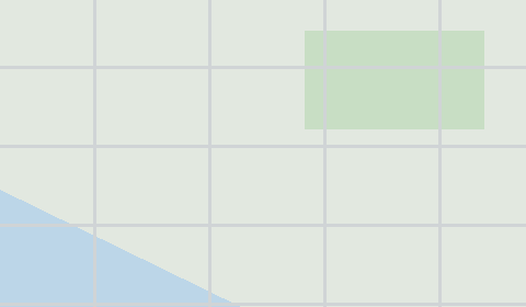
Sila ialah peta vektor siap sedia berdasarkan data OpenStreetMap. Ia bukan imej, tetapi lapisan berstruktur bangunan, jalan, badan air, kawasan hijau dan tempat menarik yang boleh disunting dalam mana-mana perisian profesional. Wilayah ini tergolong dalam rantau «Chad» dan merangkumi luas 36,263 km2 dalam sempadan pentadbiran.
Peta merangkumi 271 411 bangunan, 6 627 km jalan dan lorong dan 95 tempat menarik. Setiap lapisan boleh dihidupkan atau dimatikan sebelum muat turun, dan datanya mengekalkan pengelasan asal OpenStreetMap. Kawasan hijau meliputi kira-kira 1.4% wilayah.
Peta ini sesuai sebagai lapisan asas dalam AutoCAD dan CorelDRAW, untuk memuatkan lapisan ke QGIS dan ArcGIS, menyediakan skema dan pelan cetakan, atau sebagai asas untuk reka bentuk dan navigasi. Lebih daripada 130 format tersedia — daripada DWG, DXF dan SVG hingga GeoJSON, Shapefile dan model 3D, dalam sistem koordinat WGS 84.
Kandungan peta Sila
Peta merangkumi seluruh kawasan Sila dalam sempadan pentadbiran — 36,263 km2. Kawasan hijau meliputi 1.4% wilayah. Setiap lapisan boleh dihidupkan atau dimatikan sebelum muat turun.
Rupa peta Sila
Tempat yang sama dalam tiga gaya render. Bangunan, jalan, air dan kawasan hijau dipindahkan ke setiap format tanpa kehilangan kualiti.
Infrastruktur Sila
Apa yang ada di wilayah ini menurut data OpenStreetMap.
Kepadatan dan ketepuan
Berapa banyak ciri setiap kilometer persegi — menurut data OpenStreetMap.
Cara peta digunakan
Set data yang sama untuk Sila — untuk pelbagai tugas: daripada lukisan hingga cetakan 3D.
Alam semula jadi dan kawasan hijau
Taman, dataran dan badan air di Sila menurut data OpenStreetMap — semuanya dipindahkan ke peta sebagai lapisan berasingan.
Jalan dan lebuh
Jalan dikelaskan mengikut jenis — menurut data OpenStreetMap.
Rangkaian jalan Sila — 6 627 km jalan menurut data OpenStreetMap, dikelaskan mengikut jenis.
Restoran dan kafe
Tempat makan dan minum menurut data OpenStreetMap.
Di Sila, OpenStreetMap merekodkan 4 tempat makan dan minum — restoran, kafe, bar dan gerai makanan segera.
Kedai dan runcit
Runcit menurut data OpenStreetMap.
Di Sila, OpenStreetMap merekodkan 2 kedai dan gerai runcit. Kategori utama: Bengkel kereta, Pasar raya.
Pendidikan
Sekolah, universiti dan perpustakaan menurut data OpenStreetMap.
Sekolah: Ecole de Kadamou 1, Ecole de centre de Koukou.
Penjagaan kesihatan
Hospital, farmasi dan klinik menurut data OpenStreetMap.
Apa yang ada pada peta
Setiap lapisan peta Sila boleh dihidupkan atau dimatikan sebelum muat turun.
Angka utama
Ringkasan berdasarkan data OpenStreetMap untuk Sila.
Berbanding jiran
Bagaimana tempat ini berbanding jiran dalam radius 30 kilometer.
55 tempat dalam radius 30 km untuk dibandingkan.