osm2cdr.com
Ready map · OSM data

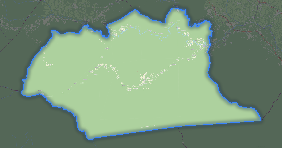
Map of East

Region · Cameroon · 108,971 km2

A ready-made vector map with buildings, roads and features — for CAD, GIS and print. Download after signing in.

Choose a format
Download · PDF, ≈ 633 KB
All 140 formats Customize your area
133 formatsOSM datadownload after signing in
N
© OpenStreetMap
Boundary · East · OpenStreetMap
BuildingsRoadsWaterGreeneryBoundary

Map passport

108,971 km2
Area
136 574
Buildings
10 455 km
Roads
252
Points of interest
Typeregion
Coordinates3.8° N, 14.21° E
Elevation≈668 m
OSM data2026-08-24
Customize the map for yourself

Open the area of East in the constructor and change layers, style, format and coordinate system for your task.

Open in constructor

Map defaults

This is how the map is built by default — every parameter can be changed in the constructor.

Format
PDF choose
Layers
Roads, Buildings, Water, Greenery, POIchange
Style
Standard (colour)change
Detail
overview (auto)change
House numbers
not visible at this scalechange
Points of interest
not visible at this scalechange
Coordinate system
WGS 84 (auto)change
Sheet size
Relief and grid

Download the map of East in 140 formats

The same OpenStreetMap dataset — in the format for your software. Pick by task: CAD, vector, GIS, 3D or print.

Popular formatsthe most common formats
MOST COMMON
PDFfor printing and viewing.pdf · 2.6 MB
CDRfor CorelDRAW.cdr · ≈ 241 KB
SVGfor Illustrator, Inkscape, web.svg · ≈ 1.8 MB
GeoJSONfor QGIS and web maps.geojson · ≈ 3.8 MB
DWGfor AutoCAD, nanoCAD, BricsCAD.dwg · ≈ 50 MB
CADdrafting and design
DWGFREE
AutoCAD.dwg · ≈ 50 MB
DXFFREE
CAD exchange.dxf · ≈ 123 MB
CDRFREE
CorelDRAW.cdr · ≈ 142 KB
DGNFREE
MicroStation.dgn · ≈ 633 KB
Vectorillustration and web
SVGFREE
Web · vector.svg · ≈ 1.1 MB
AIFREE
Illustrator.ai · ≈ 890 KB
EPSFREE
Print production.eps · ≈ 869 KB
PDFFREE
Vector · print.pdf · 2.6 MB
GISgeo-referenced data
GeoJSONFREE
GIS · data.geojson · ≈ 1.9 MB
ShapefileFREE
QGIS · ArcGIS.shp · ≈ 251 KB
KMLFREE
Google Earth.kml · ≈ 1.9 MB
GeoPackageFREE
GeoPackage.gpkg · ≈ 1.1 MB
3Dvolume and models
STLFREE
3D printing.stl · ≈ 61 KB
OBJFREE
3D model.obj · ≈ 24 KB
glTFFREE
3D · web.gltf · ≈ 44 KB
DAEFREE
Collada.dae · ≈ 40 KB
Printraster and layouts
PNGFREE
Raster · transparency.png · ≈ 728 KB
JPGFREE
Raster.jpg · ≈ 185 KB
PDFFREE
Print layout.pdf · 2.6 MB
TIFFFREE
Print production.tif · ≈ 1.7 MB
Open all 140 formats

Maps of Cameroon

All places within the territory — every map is ready to download.

Neighbouring places and regions

Browse to neighbouring cities, districts and regions — each has a ready-made vector map in the same formats.

Other places in Cameroon

CentreFar-NorthSouthNorthSouthwestAdamawaLittoralWestNorthwest
All places in Cameroon

Neighboring regions

CentreRegionFar-NorthRegionSouthRegionNorthRegionSouthwestRegionAdamawaRegionLittoralRegionWestRegionNorthwestRegion
Map of East
East
Cameroon

About East

East is a ready-made vector map based on OpenStreetMap data. It is not an image but structured layers of buildings, roads, water bodies, greenery and points of interest that can be edited in any professional software. The territory belongs to the «Cameroon» region and covers an area of 108,971 km2 within administrative boundaries.

The map includes 136 574 buildings, 10 455 km of roads and streets and 252 points of interest. Each layer can be turned on or off before download, and the data preserves the original OpenStreetMap classification. Green areas cover about 90.8% of the territory.

The map works well as an underlay in AutoCAD and CorelDRAW, for loading layers into QGIS and ArcGIS, preparing printed schemes and plans, or as a basis for design and navigation. More than 130 formats are available — from DWG, DXF and SVG to GeoJSON, Shapefile and 3D models, in the WGS 84 coordinate system.

136 574buildings
10 455 kmroads and streets
252features
140formats
WGS 84coordinate system

What's inside the map of East

The map covers the entire area of East within administrative boundaries — 108,971 km2. Green areas cover 90.8% of the territory. Each layer can be turned on or off before download.

136 574buildings
Buildings on separate layers
commercial40
industrial9
10 455km
Roads with classification
trunk roads1 487 km
primary roads556 km
service roads69 km
252POI
Points of interest
bars6
banks6
fuel stations13
Main streets
Mboy-LibongoBatouri-KetteItalie-NgaîkadaMango Tree RoadAvenue Paul BiyaPont de Touraké
Landmarks · 6
›WWF Ikwa camp
›Carrière Kuete Bedell client bertoua
›Place des fêtes de Lomié
›Grotte a chauves souris de Mokok Menteng
›Gassimi
›Ngwan

What the map of East looks like

The same place in three render styles. Buildings, roads, water and greenery carry over into every format losslessly.

Blueprint (CAD) — map of East
Blueprint (CAD)
Outlines on a dark background — for DWG and DXF
Standard vector — map of East
Standard vector
A colour map with buildings, roads and greenery
Print layout — map of East
Print layout
A ready layout for PDF and print production

Infrastructure of East

What's on the territory according to OpenStreetMap data.

10
Dining
20
Shops
15
Hotels
16
Transport
5
Parks
6
Water

Density and saturation

How many features there are per square kilometre — according to OpenStreetMap data.

1
bld/km²
0,1
km/km²
0
POI/km²
90,8%
greenery

How the map is used

The same dataset for East — for different tasks: from drafting to 3D printing.

Architecture and design
An underlay and building outlines for drawings and layouts.
DWG / DXF
Design and illustration
A vector map base for posters, schemes and identity design.
SVG / AI
GIS and analysis
Geo-referenced layers for QGIS, ArcGIS and spatial analysis.
GeoJSON / SHP
3D printing and models
Relief of buildings and terrain for printing and visualization.
STL
Navigation and tracks
Map data for navigators and route apps.
Garmin
Print and publishing
A ready map layout for print production.
PDF

Landmarks

Museums, monuments and notable places of East according to OpenStreetMap data — each with a link to the map.

⭐
WWF Ikwa camp
AttractionOSM
⭐
Carrière Kuete Bedell client bertoua
AttractionOSM
⭐
Place des fêtes de Lomié
AttractionOSM
⭐
Grotte a chauves souris de Mokok Menteng
AttractionOSM
⭐
Gassimi
AttractionOSM
⭐
Ngwan
AttractionOSM
⭐
Stade communautaire
AttractionOSM
⭐
Marché de Ngoap
AttractionOSM
⭐
WWF Yumbi bai field base
AttractionOSM
⭐
Jetty for Bomandjokou
AttractionOSM
⭐
WWF Ponda Camp
AttractionOSM
🗿
Statut de J Atangana Mpene
MonumentOSM
⛪
EPC de Bedoumo
Place of worshipOSM
⛪
Eglise Catholique Bedoumo
Place of worshipOSM
⛪
EEC PAROISSE D'ENIA
Place of worshipOSM

Nature and green areas

Parks, squares and water bodies of East according to OpenStreetMap data — everything is carried into the map as separate layers.

90,8%
green coverage
5
parks
6
water bodies
Parks and squares
›Palmerais · 1 ha
›ESPACE VERT 4 · 0 ha
›ESPACE VERT 1 · 0 ha
›ESPACE VERT 3 · 0 ha
›ESPACE VERT 5 · 0 ha
Water bodies
›Lac du barrage de Lom Pangar · lake
›Boumba · lake
›Lom · lake
›Dja · river
›Kadéï · river
›Bek · river

Public transport

Stops and stations according to OpenStreetMap data.

11
bus stops
5
rail stations

Public transport of East includes 11 bus stops and 5 rail stations. All stops and stations are included in the map as a separate layer.

Streets and roads

Roads classified by type — according to OpenStreetMap data.

2418,8 km
unclassified roads
2393,1 km
tertiary roads
1884,9 km
residential streets
1641,6 km
secondary roads
1487,5 km
trunk roads
556,8 km
primary roads
69,8 km
service roads
2,7 km
living streets

The street network of East — 10 455 km of roads according to OpenStreetMap data, classified by type.

Named streets
›Mboy-Libongo · 169 km
›Batouri-Kette · 60 km
›Italie-Ngaîkada · 3,7 km
›Mango Tree Road · 1,3 km
›Avenue Paul Biya
›Pont de Touraké

Restaurants and cafés

Food and drink venues according to OpenStreetMap data.

1
restaurants
6
bars
2
fast food

In East, OpenStreetMap records 10 food and drink venues — restaurants, cafés, bars and fast-food outlets.

Notable venues
›Le couscoucier

Shops and retail

Retail according to OpenStreetMap data.

20
shops

In East, OpenStreetMap records 20 shops and retail outlets. Main categories: Convenience, Bakeries, Mobile Phones, Pet Shops, Wine, Clothes.

Convenience5Bakeries2Mobile Phones2Pet Shops1Wine1Clothes1Seafood1Copy Shop1Beverages1Supermarkets1

Education

Schools, universities and libraries according to OpenStreetMap data.

38
schools
2
universities
4
kindergartens

Schools: Ecole Primaire de Kagnol, Lycée technique de NKOLBIKON, Ecole Publique Bertoua 2, CES Bertoua2, Ecole catholique de Bertoua 2, école gadji, Virage très dangereux, École Primaire Publique groupe 2. Universities: Ecole des infirmiers, École publique primaire de Libongo.

Healthcare

Hospitals, pharmacies and clinics according to OpenStreetMap data.

5
hospitals
6
pharmacies
8
clinics

Hospitals of East: CENTRE DE SANTE LUMEN-CHRISTI, Hôpital de district de Lomié, District de santé de Lomié, Hôpital de district de Lomié, Hôpital Privé catholique de Lomié.

Where to stay

Hotels, hostels and guest houses according to OpenStreetMap data.

15
accommodation places
Hotels and guest houses
›Motel le Kadey · Hotel
›domicile bas bertoua · Apartments
›Hôtel le Confluent · Hotel
›Cible · Guest house
›Dr Atangana dorine · Guest house
›Christianna Hotel · Hotel
›Hotel Sun City · Hotel
›ATRAS SAHAGUE · Guest house

What's on the map

Each layer of the East map can be turned on or off before download.

Map layers
›Buildings: 136 574
›Roads: 10 455 km
›Points of interest: 252

Key figures

A summary based on OpenStreetMap data for East.

Buildings136 574
Commercial buildings40
Roads10 455 km
Green coverage90,8%
Food and drink venues10
Shops20
Points of interest252
Bus stops11
Rail stations5
Hospitals5
Pharmacies6
Landmarks15

Compared to neighbours

How the place compares to neighbours within a 30-kilometre radius.

13 places within a 30 km radius to compare.

🛣️ Roadspercentile 0 of 100

Frequently asked questions

Open osm2cdr.com, select the target area on the map, choose a format, and start export. Most maps are ready in a few seconds.
Map of East is available in 140 formats: CDR, DWG, DXF, SVG, AI, EPS, PDF, PNG, GeoJSON, KML, Shapefile, GeoTIFF and others.
Pick a format: all 140 formats are available, with no area limits. Download after signing in to the site; you see the price before you pay.
The service uses OpenStreetMap data, updated monthly.
Generation time depends on the area size. You will receive an email notification when ready.