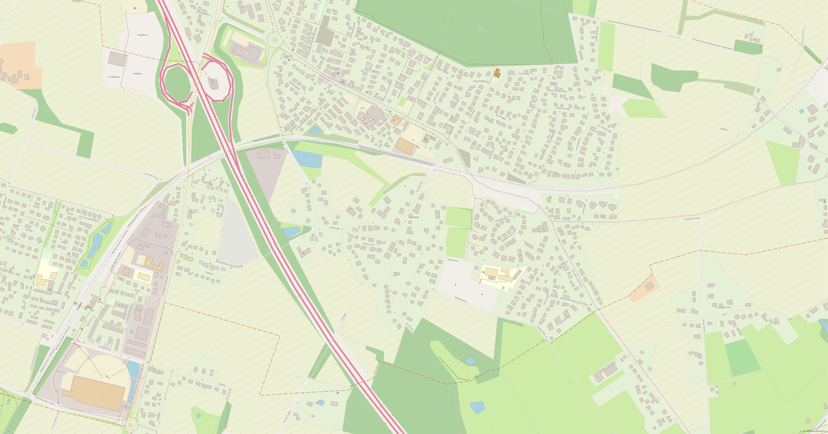
Map of Fleestedt in EPS format
OpenStreetMap డేటా నుండి నిర్మించిన మ్యాప్, డౌన్లోడ్కు సిద్ధంగా ఉంది
మ్యాప్ను మీకు తగినట్లుగా అమర్చండి
ఈ ప్రదేశ ప్రాంతాన్ని కన్స్ట్రక్టర్లో తెరిచి మీ అవసరాలకు అనుగుణంగా అన్నీ సర్దుబాటు చేయండి
కన్స్ట్రక్టర్లో తెరవండి →మ్యాప్ పాస్పోర్ట్
ఈ మ్యాప్లో డిఫాల్ట్గా ఏమి ఉంది
మ్యాప్ «ఉన్నది ఉన్నట్లుగా» ఇలా నిర్మించబడుతుంది — ప్రతి సెట్టింగ్ను కన్స్ట్రక్టర్లో మార్చవచ్చు.
.eps
EPS గురించి
Fleestedt మ్యాప్ EPS ఫార్మాట్లో: 511 భవనాలు, 17 కి.మీ రోడ్లు, 53 ఆసక్తి బిందువులు, 100% పచ్చని ప్రాంతాలు — WGS 84 నిర్దేశాంక వ్యవస్థలో, యూనిట్లు మీటర్లు.
ఫైల్లో ఏ పొరలు ఉన్నాయి
ఎంచుకున్న ప్రాంతం కోసం ఈ ఫైల్లో ఉన్నవి:
- రోడ్లు
- భవనాలు
- నీరు
- పచ్చదనం
- ఆసక్తి బిందువులు
పొర వారీగా జ్యామితి
- రోడ్లు — రోడ్డు తరగతిని బట్టి మందం మరియు రంగు గల రేఖలు
- భవనాలు — నింపిన భవన ఆకృతులు
- నీరు — నింపిన విస్తీర్ణ ఆకృతులు మరియు తీర రేఖలు
- పచ్చదనం — పచ్చని ప్రాంతాల నింపిన విస్తీర్ణ ఆకృతులు
- ఆసక్తి బిందువులు — చిహ్నాలు మరియు వర్గ లేబుళ్లు
ఫైల్ ఏమి మోసుకెళ్తుంది
Fleestedt కోసం EPS ఫైల్: అంశాలు పేరు గల పొరలుగా విభజించబడ్డాయి, OpenStreetMap ట్యాగ్లు భద్రపరచబడవు — జ్యామితి మరియు రూపకల్పన మిగులుతాయి.
ఫైల్ పరిమాణం
Fleestedt కోసం EPS ఫైల్ ఆశించిన పరిమాణం సుమారు 750 KB; కచ్చితమైన పరిమాణం ఎంచుకున్న పొరలు మరియు ప్రాంతంపై ఆధారపడి ఉంటుంది.
నిర్దేశాంక వ్యవస్థలు
WGS 84 (EPSG:4326), విజార్డ్లో ఎంచుకోదగినది
అనుకూలత
కొలత యూనిట్లు
మీటర్లు (ఎంచుకున్న నిర్దేశాంక వ్యవస్థలో ప్రొజెక్ట్ చేయబడింది)
| వర్గం | Vector |
| ఫైల్ పొడిగింపు | .eps |
| స్థాయి | Open Beta |
What's in the EPS map of Fleestedt
511 buildings (16 residential, 2 commercial, 1 religious), 16.9 km of roads, 53 points of interest, 1 landmarks.
The area covers 1.2 km², with about 431 buildings per km².
Mostly residential streets 10.8 km, service roads 3.2 km, motorways 1.8 km.
The map marks 1 water bodies.
Key amenities: schools — 1, kindergartens — 2, doctors — 4.
Public transport: 5 bus stops.
EPS map contains 511 buildings and 16.9 km of roads. Ready for professional printing and layout.
Main streets: Winsener Landstraße, Am Försterland, Kirchweg, Im Alten Dorf, Osterkamp
Landmarks: Christuskirche
Fleestedt కోసం EPS ను ఎలా ఉపయోగించాలి
- హోమ్ పేజీలో Fleestedt మ్యాప్ ప్రాంతాన్ని ఎంచుకోండి
- EPS ఫార్మాట్ను ఎంచుకుని ఎగుమతి సెట్టింగ్లను కాన్ఫిగర్ చేయండి
- «Export» నొక్కి ప్రాసెసింగ్ పూర్తయ్యే వరకు వేచి ఉండండి
- సిద్ధమైన ఫైల్ను డౌన్లోడ్ చేసి మీ అప్లికేషన్లో ఉపయోగించండి